Orissa part of Ranchi-Vijaywada highway – call for consultants
Vijaywada-Ranchi highway March 18th. 2008, 8:27amSome of the information on this is available at:
- http://morth.nic.in/writereaddata/noticeimages/Corrigendum_I3643744755.pdf
- http://morth.nic.in/writereaddata/noticeimages/Clarifications%20on%20RFP3580070101.pdf
- http://morth.nic.in/writereaddata/noticeimages/Ultimate_RFP4418252769.pdf
The following is an excerpt from http://morth.nic.in/writereaddata/noticeimages/Ultimate_RFP4418252769.pdf.
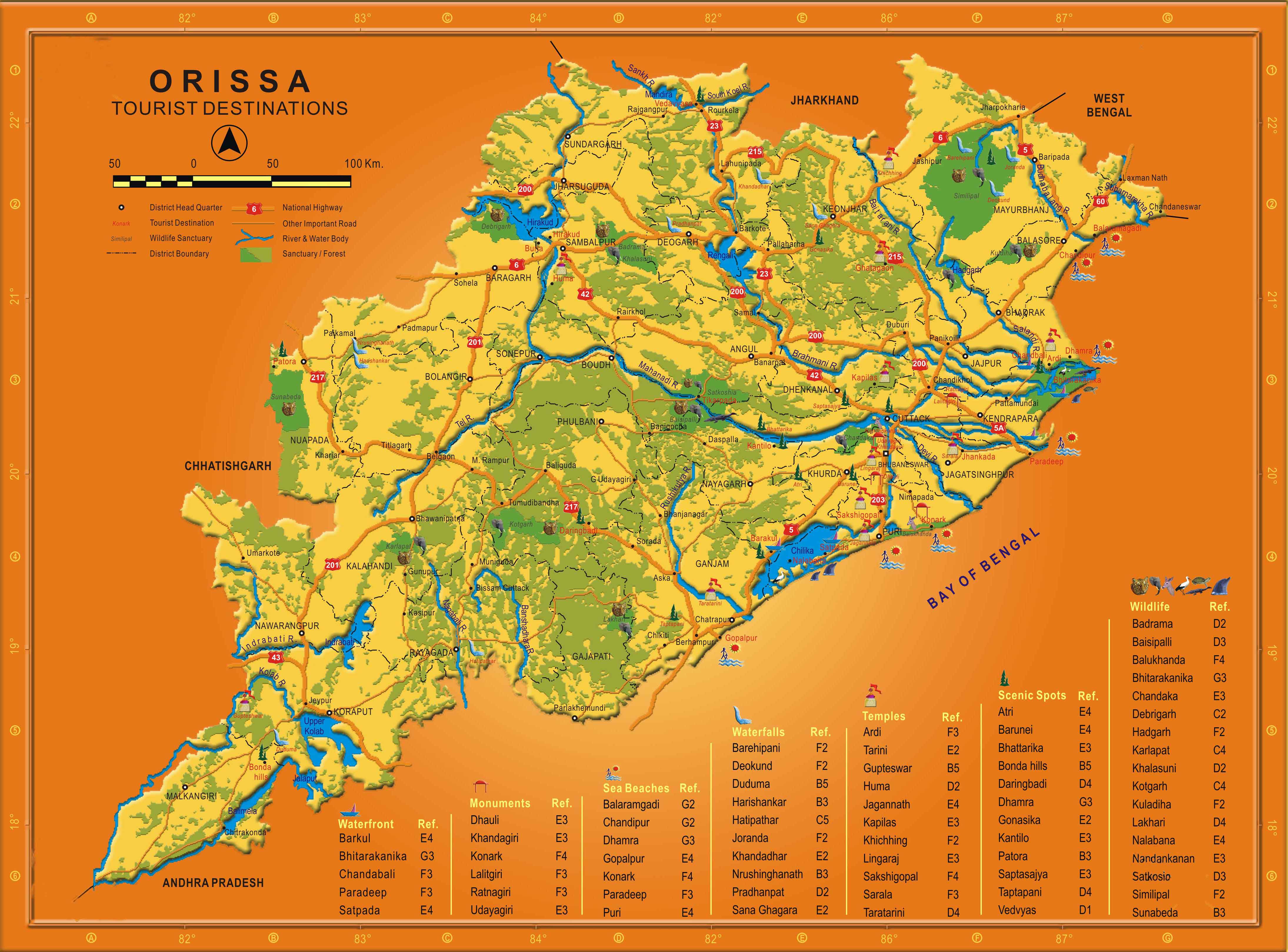
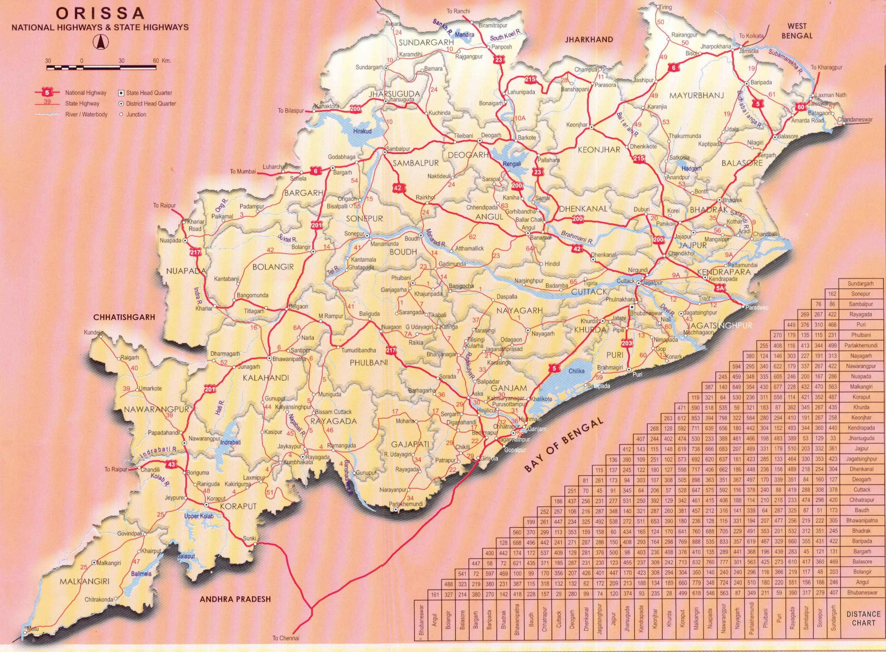
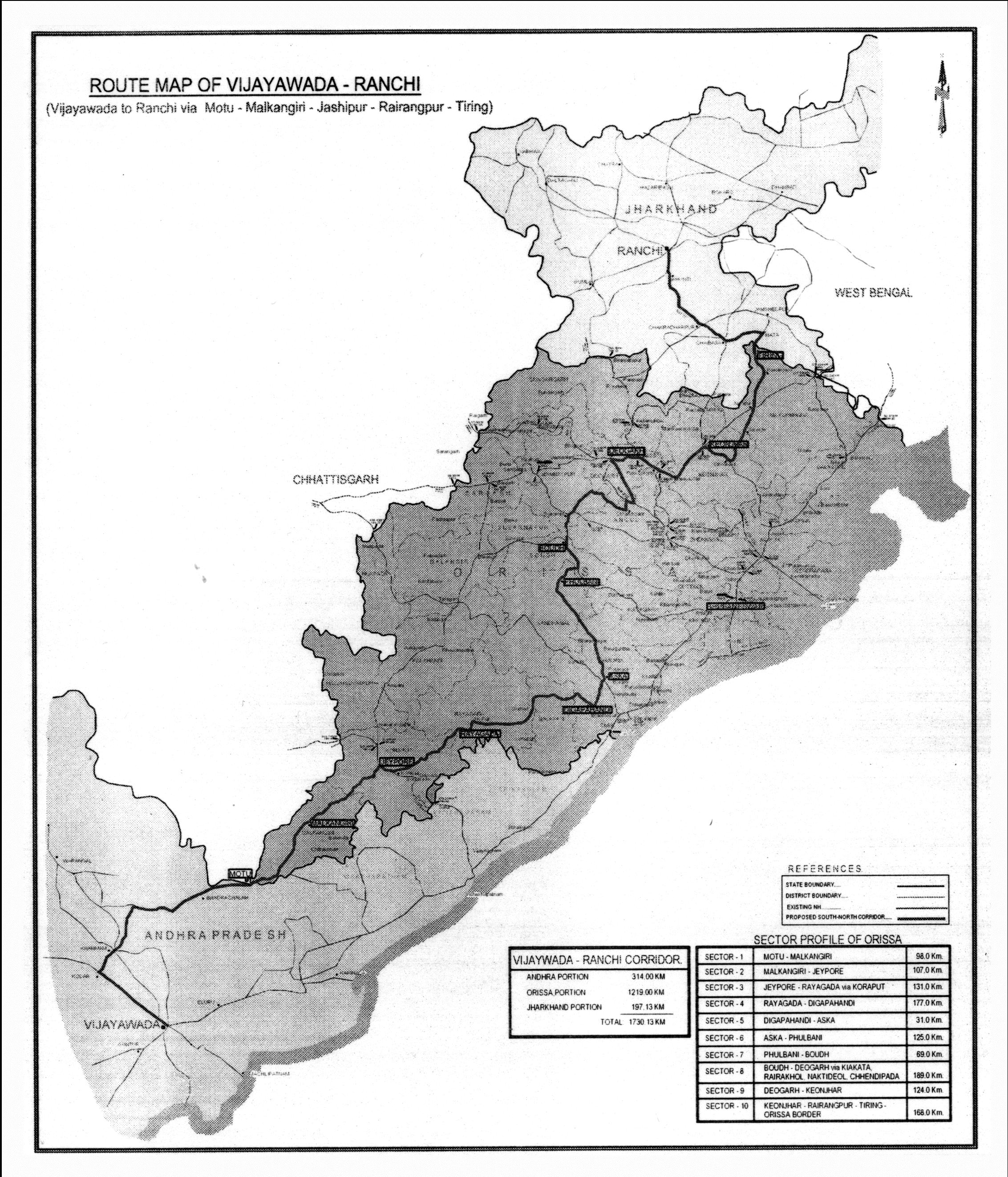
The Government of India with the cooperation of State Government intends to improve the communication infrastructure in the back ward area affected by naxalites and bring the backward area to the mainstream by removing the development disparity. This road has been planned to combat extremist activities in the border districts of Orissa as well as social upliftment of tribal people. The road from Vijayawada enters in Orissa at Motu in Malkangiri in south Orissa and leaves the State near Tiring in Mayurbhanj District in the north. The proposed road passes through 12 backward districts of Orissa. This road traverses through different topography. The route virtually passing middle of the State longitudinally, has been chosen carefully after identifying the disturbed area. Construction of this road shall help to bring about radical changes in the life style of the tribal people of the State, who often are subjected to coercion by extremists, by bringing in improved economic activities and improved law and order situation.
Most of the roads stretches are deficient in lane width, crust, formation height, drainage, CD works etc. It is necessary to work out an improvement strategy depending on sound engineering practice whereby all the weak points of road is attended to. Therefore, it is decided to engage Domestic Consultants to carry out the detailed project preparation for the roads & bridges by updating / redoing the available engineering data and supplementing with further investigation and data. The proposed improvement works shall consist mainly in raising the formation level, widening to two-lane from the existing single-lane/ intermediate-lane width, pavement strengthening and improving the cross drainage works. The road alignment comprises of predominantly single lane State Roads and Below Standard single lane in rural roads and DL/IL in NH stretches. The average formation width also varies considerably from 5m in Rural roads to 8 to 10m in State roads and 10-12m in NHs.. The Right of way also varies from 10m in the rural roads to 15-20m in SH/DR to 30-45m in NH. Most of the road stretches do not have appropriate geometrics. Some of the stretches have also deficient formation height.
The road is having a total length of 1219 km consisting of NH, SH, District roads and Village roads. Government of Orissa from its own resources have already started preparation of DPR of about 163 km of roads. Leaving aside the NH portion of the alignment, which will be taken up subsequently, it is decided to take up preparation of Detailed Project Report along with bid documents for balance about 600 km of SH and other category of roads. For convenience of administration, this 600 km of road has been divided to ten packages; the details of stretches which are included in the scope of work are provided in the Annexure-I.
The State of Orissa experiences annual rainfall of about 1500 mm and the maximum temperature during the summer from April to June is about 45 degree Celsius and minimum during winter from November to January is about 7 degree Celsius. The alignment is away from coastal area and the closest to the sea location is Aska and Digapahandi which will be about 50km from Bay of Bengal. The alignment is passing through predominantly plain/rolling terrain and hilly terrain.
2. OBJECTIVES The objectives of this consultancy services would be to carry out, feasibility study, detailed engineering design and project preparation (including BOQ, Bid documents and preparation of quality control manual for supervision) for the specific package indicated in Annexure-I. All the roads shall be improved to two lane carriageway with or without paved shoulder depending on the composition of traffic.
Accordingly, the objectives of this consultancy package will include: The feasibility study shall inter alias include traffic surveys, analysis and growth projections, fixing broad contour of the project, working out widening, realignment, bypass options, working out pavement rehabilitation/reconstruction options, working out rehabilitation/reconstruction options for bridges and CD works, working out schemes for various improvement features like intersections, service roads, underpasses, bus bays etc, environmental and social screening of the project and determination of preliminary cost of the project and carrying out economic analysis. Detailed Engineering Design and Project Preparation shall inter alias include detailed highway design (alignment plan and profile), design of pavement, design of bridges and CD works, design of other improvement works and road furniture, environmental and social safeguard plans, detailed working drawings, detailed cost estimate, BOQ, Economic Analysis, and Bid Document Preparation.


.jpg)
April 15th, 2011 at 3:38 am
Apply post of QUALITY CONTROL ASST.MATERIAL ENGINEER
B.Tech civil exp.12 yrs Total exp.is Highway road constructions