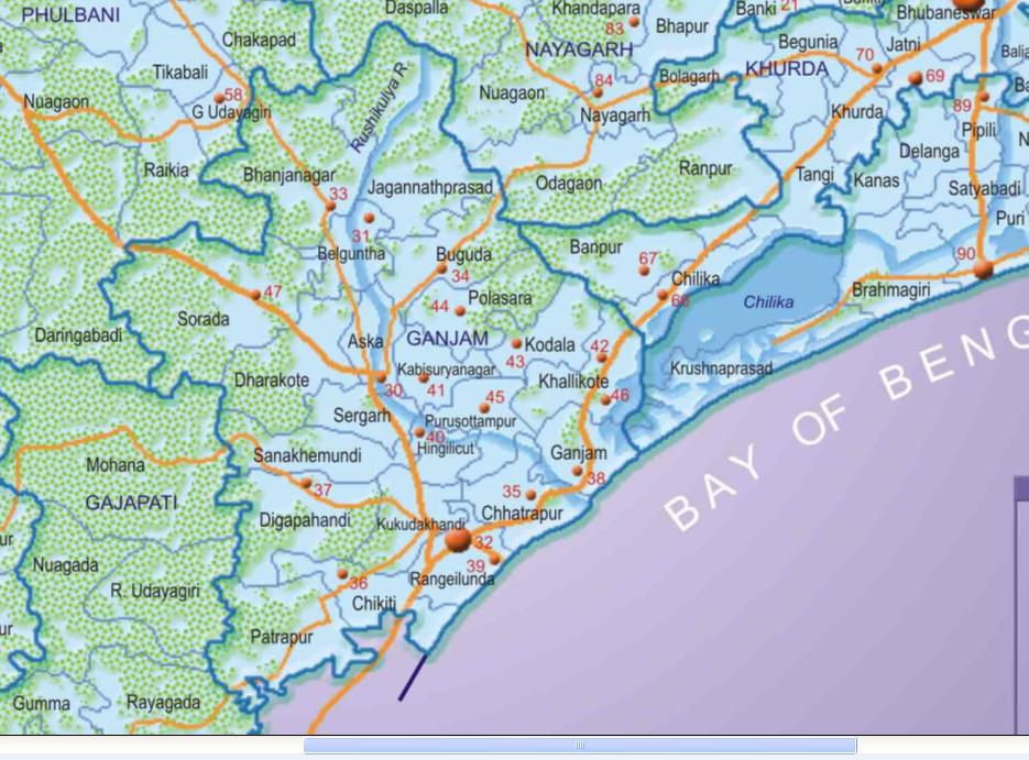
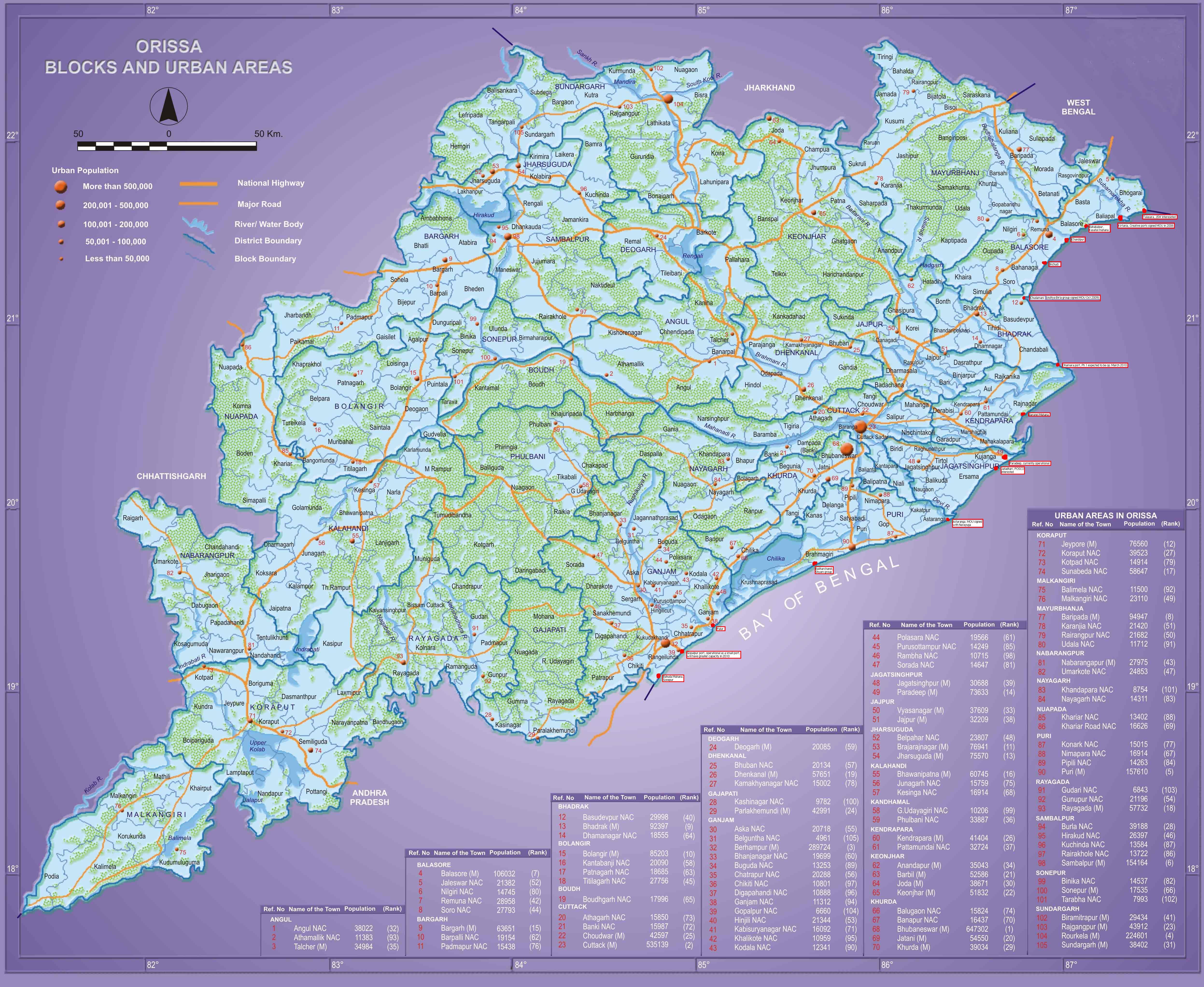
In Orissa, Ganjam district has the most number of urban centers
Berhampur- Gopalpur- Chhatrapur, Ganjam October 16th. 2009, 8:36amIf one looks at the map of population centers in Orissa, Ganjam district seems to have the maximum number of urban centers.
The following is with respect to the 2001 cesnus.
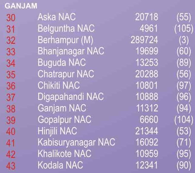
As per the 2009 estimate the urban areas of Ganjam with a population of more than 7500 are:
| 1 | Brahmapur | 210 418 | 307 792 | 402 672 |
| 2 | Hinjilikatu | 17 676 | 21 347 | 24 229 |
| 3 | Chatrapur | 17 952 | 20 289 | 21 892 |
| 4 | Bhanjanagar | 17 122 | 19 748 | 21 641 |
| 5 | Polasara | 16 854 | 19 568 | 21 553 |
| 6 | Aska | 19 363 | 20 739 | 21 478 |
| 7 | Kavisuryanagar | 13 938 | 16 094 | 17 652 |
| 8 | Sorada | 13 268 | 14 648 | 15 525 |
| 9 | Buguda | 10 664 | 13 257 | 15 383 |
| 10 | Purushottampur | 12 904 | 14 249 | 15 105 |
| 11 | Kodala | 10 187 | 12 345 | 14 049 |
| 12 | Khalikote | 9 071 | 10 958 | 12 441 |
| 13 | Rambha | 9 213 | 10 716 | 11 819 |
| 14 | GanjÄm | 10 847 | 11 317 | 11 488 |
| 15 | Digapahandi | 10 032 | 10 890 | 11 395 |
| 16 | Chikitigarh | 10 005 | 10 802 | 11 256 |
| 17 | Belaguntha | 8 838 | 9 962 | 10 727 |
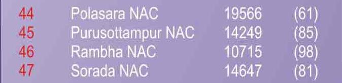
| 18 | Lochapoda | 9 240 | 10 123 | |
| 19 | Golabandha | 8 549 | 9 366 | |
| 20 | Arjyapalli | 7 768 | 8 511 | |
| 21 | Sundarpur | 7 601 | 8 328 | |
| 22 | Suvani | 7 424 | 8 134 | |
| 23 | Gopalpur | 5 451 | 6 663 | 7 633 |
| 24 | Mardamekha | 6 955 | 7 620 | |
| 25 | Bhatakumarada | 6 900 | 7 560 |
Ganjam is the only district in Orissa to have two Lok Sabha constituencies named after its towns/cities: Berhampur and Aska.
Based on the above the state, district and city planners should plan on creating larger urban agglomerations so that they can get more funding and infrastructure. In particular, the larger the urban area, the more is the funding from the urban development ministry.
In particular, the Berhampur area should be planned to grow radially:
- To the North east on NH-5 towards Chhatrapur, Rushikulya river and Chilika lake
- To the east to Gopalpur
- To the North on NH-217 towards Hinjilicut (the second largest urban area of Ganjam and the CM Naveen babu’s constituency)
- To the west towards Digapahandi
- To the southwest towards Chikiti
- To the south towards Andhra border
An initial start in this direction has been made. But the area needs to be made bigger. See below.
.jpg)
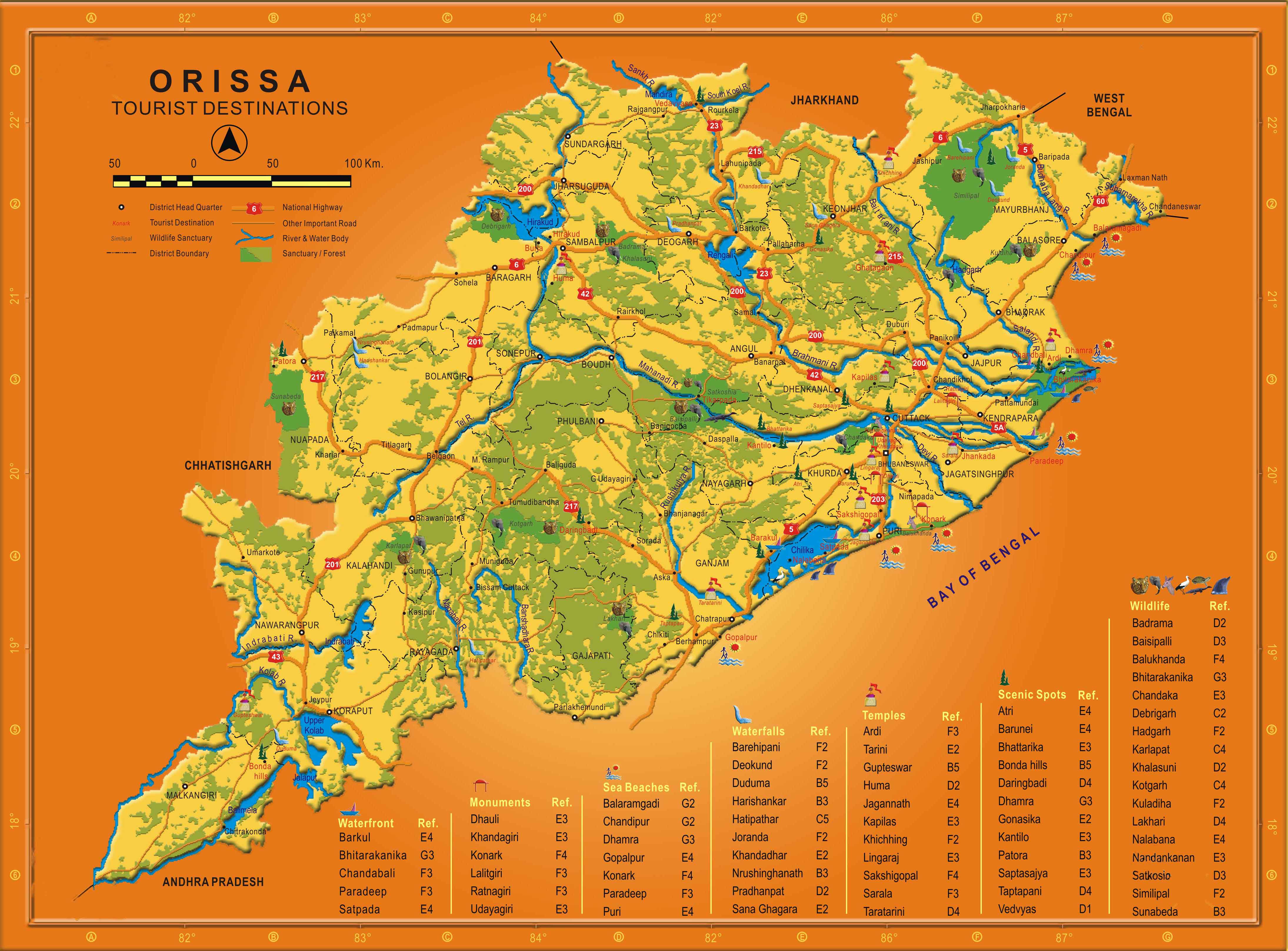
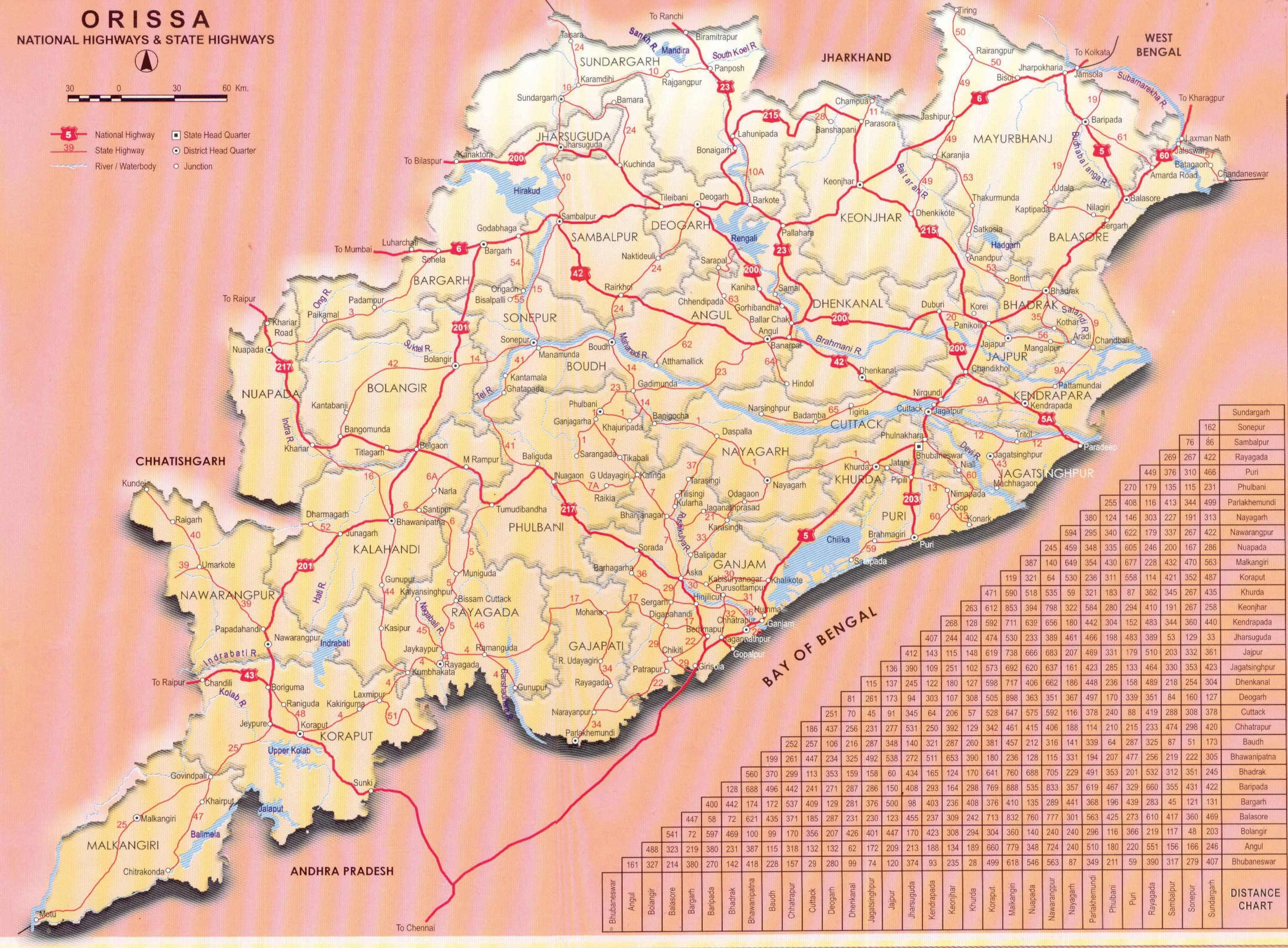
If one looks at the map of roads in Orissa, Ganjam district seems to be the most dense with roads. Looking at the above map an initial metro area bounded by Berhampur, Hinjilicut, Chhatrapur and Gopalpur would be good. The Rushikulya river frontage and the beach areas could serve as scenic demarcations.
In terms of other developments, the Future Berhampur blog lists the various development taking place in Berhampur. Some of the notable ones are:
- The number of educational institutions in the area, especially through private ventures. (For example, 7 diploma granting polytechnics, NTTF center, 10 engineering colleges, etc.)
- Gopalpur port
- Tata SEZ in Gopalpur
- Planned atomic power plant
- Planned IIIT Berhampur
This is a good core to start with. With proper planning and attention the Berhampur area could become a Tier-II metropolitan area of India. Its distance to the Bhubaneswar area is similar to the distance of Pune from Mumbai and Mysore from Bangalore.


.jpg)
October 19th, 2009 at 3:06 am
The idea of building bigger urban clusters is really wonderful. Infact, this should be done as soon as possible and prior to the census 2001. Only thing is instead of taking the core city population for census 2001, it must consider the semi-urban peripherey areas as well so that we have the real picture of the population of bigger urban area. AP has done this much before and hence we see Greater Visakhapatnam and Greater Hyderabad etc.
October 19th, 2009 at 10:40 am
Have a look at http://www.orissa2020.org/urban-agglomerations-of-orissa and suggest me small towns in Gazetteer-Orissa or Gazetteer-Ganjam that I should add to the greater Berhampur area.
October 20th, 2009 at 3:50 am
The following urban centers are either a part of present Berhampur city or are located close to it. Strangely some pockets inside Berhampur city were till recently considered as village with population in the range of 5-10 thousand.
Berhampur (core) – 402672
Hinjilikatu (NAC) – 24229
Chatrapur (NAC) – 21892
Under BMC
Lochapada (inside Berhampur) – 10123
Bhabinipur (Under BMC limits) – 7324
Lathi (Under BMC limits) – 6479
Jagadalpur (Under BMC limits) – 5868
Mohada (inside BMC) – 3265
Berhampur East City
Golabandha (Military cantonment) – 9366
Arjyapalli (Gopalpur port) – 8511
Gopalpur (NAC) – 7633
Pathara (Under BMC limits) – 5692
Korapolli (BAMP-Gopalpur) – 3540
Rangilunda (Berhampur University) – 2493
Berhampur South City
Golanthara (NIST) – 5345
Konisi (inside BMC)- 4210
Haldiapadar (under BMC and AutoNagar) – 2762
Randha (cluster of Engineering colleges) – 2703
Places close to Berhampur with educational or other Instiutions
Sundarpur (Engineering colleges) – 8328
Kukudakhandi (less than 5 kms) – 7073
Ankusapur (SMIT & inside Berhampur)- 4743
Narendrapur (Govt eng college & inside BMC)- 3470
Bendalia (inside BMC)- 2920
Matikhala (IRE)- 2852
Chamakhandi (TATA)- 2638
Chandipadar (SMIT Eng College)- 2467
Mandiapalli (JN TATA Institute) – 2303
Nimakhandi (inside Berhampur) – 2929
————————————————
Greater Berhampur Total: 573830 (Excluding few other Panchayats which have since been subsumed under BMC)
Likely population of Greater Berhampur in 2011: 6 Lakh and among top 80 cities of India and as the 2nd/3rd largest urban cluster of Orissa.
PS: wrote 2001 census instead of 2011 in the previous post. May kindly be corrected
October 20th, 2009 at 5:00 am
The idea of implementation of planning process to urban agglomerations is indeed essential. However I would believe prevention of rural to urban migration by provision of adequate facilities in villages and strengthening agriculture and cottage industries would be a better policy measure. However town planning should be given the highest of priorities.
April 20th, 2010 at 10:05 pm
this is vere good web sait