SER needs to have a division HQ in Odisha (possibly in Rourkela) as more than 22% (and growing) of its route kms lie in Odisha; and without a proper voice from Odisha SER has been neglecting and making blunders in Odisha (work in progress)
APPEAL to readers, Balasore, Balasore-Baripada-Rasgovindpur, Baripada - Bangiriposi (under constr.), Keonjhar, Mayurbhanj, Rourkela- Kansbahal, Rupsa Jn - Baripada, SER, Sundergarh November 20th. 2011, 3:17amPlease help me fill the missing data in the table below. (The important data we need is the route kms for the red states in Column 2 as those states do not have a division HQ of that zone.)
| Zones, Zone HQ (Route kms from page 13 of 2009-10 yearbook) | States where the zones lie (Route km break up) | Division HQs and states they lie in |
| Central, Mumbai (3905) [wiki,home,map] | Maharashtra, Karnataka, MP. | Bhusawal, Mumbai, Nagpur, Pune, Solapur (all Maharashtra) |
| Eastern, Kolkata (2414) [wiki,home,No map] | West Bengal, Bihar | Asansol, Howrah, Malda, Sealdah (all West Bengal) |
| East Central, Hazipur (3628) [wiki,home, No map] | Bihar, Jharkhand, UP | Danapur (Bihar), Dhanbad (Jharkhand), Mughalsarai (UP), Samastipur (Bihar), Sonpur (Bihar) |
| ECOR, Bhubaneswar (2572) [wiki,home,map] | Odisha (1807.25), Chhatisgarh (268.50), AP (570.64)=2646.39 [from map] | Khurda Rd (Odisha), Sambalpur (Odisha), Visakhapatnam (AP) |
| Northern, New Delhi (6968) [wiki,home,map] | Punjab, Delhi, UP, J & K, Haryana, Himachal Pradesh, Uttaranchal, Rajasthan, Chandigarh | Ambala (Haryana), Delhi, Firozpur (Punjab), Lucknow (UP), Moradabad (UP) |
| North Central, Allahabad (3151) [wiki,home,map] | UP, MP, Rajasthan, Haryana | Agra, Allahabad, Jhanshi (all UP) |
| North Eastern, Gorakhpur (3667) [wiki,home] | UP, Uttaranchal, Bihar | Izzatnagar (UP), Lucknow (UP), Varanasi (UP) |
| Northern Frontier, Guwahati (3907) [wiki,home,India map] | WB, Bihar, Assam, Tripura, Manipur, Nagaland, Mizoram, Arunachal Pradesh | Alipurdar (WB), Katihar (Bihar), Lumdig (Assam), Rangiya (Assam), Tinsukia (Assam) |
| North Western, Jaipur (5459) [wiki,home,map] | Rajasthan, Punjab, Haryana, Gujarat, MP. | Ajmer, Bikaner, Jaipur, Jodhpur (all Rajasthan) |
| Southern, Chennai (5098) [wiki,home] | Tamil Nadu, Kerala, Pondicherry | Chennai (TN), Madurai (TN), Palghat (Kerala) Trichi (TN), Trivendrum (Kerala) |
| South Central, Secunderabad (5803) [wiki,home,map] |
AP (4348.4), Maharashtra (1115.8), MP (70.2), Tamil Nadu (6.9), Karnataka (268.7) = 5810 |
Guntakal (AP), Guntur (AP), Hyderabad (AP), Nanded (Maha), Secunderabad (AP), Vijaywada (AP) |
| SER, Kolkata (2631) [wiki,home] |
West Bengal, Jharkhand, Odisha (589+) 2004 data: West Bengal (894), Jharkhand (954), Odisha (574.6) = 2422.6 |
Adra (WB), Charadharpur (Jharkhand), Kharagpur (WB), Ranchi (Jharkhand) |
| SE Central, Bilaspur (2447) [wiki,home,no map] |
Chhatisgrh (891.3), Maharashtra (662.3), Odisha (51.1), MP (792.5) = 2397.3 Total [From a 2005 map] But BG distribution is as follows: |
Bilaspur (Chhatisgarh), Raipur (Chhatisgarh), Nagpur (Maharashtra) |
| South Western, Hubli (3177) [wiki,home,map] | Karnataka (2702.6), Andhra Pradesh (224.2), Tamil Nadu (174.3), Maharashtra (27.9), Goa (69.3) = 3198.3 [from map] | Bangalore, Hubli, Mysore (all Karnataka) |
| Western, Mumbai (6182) [wiki,home,map] | Gujarat, Maharashtra, MP, Rajasthan. | Ahmedabad (Gujarat), Bhavnagar (Gujarat), Mumbai (Maha), Ratlam (MP), Rajkot (Gujarat), Vadodara (Gujarat) |
| West Central, Jabalpur (2965) [wiki,home,map] | MP, Rajasthan | Bhopal (MP), Jabalpur (MP), Kota (Rajasthan) |
Why it is important that SER have a division in Odisha?
- As we will show below SER, without a proper representation in Odisha, has badly messed up in Odisha.
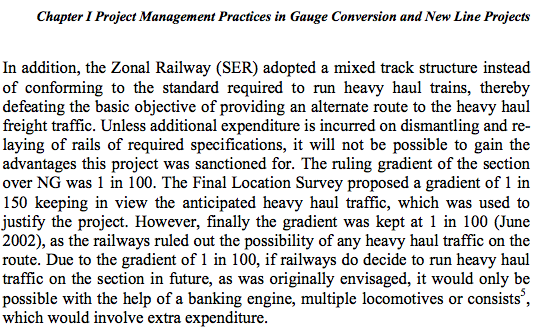
- SER has neglected stations in Odisha. In particular, it has neglected Rourkela, the second largest metropolitan area of Odisha in many ways. For example, Rourkela is not in the list of world-class stations.
How has SER messed up in Odisha?
- The Rupsa-Bangiriposi conversion to broad gauge has been messed up badly. See page 8-9 of 2006-may-CAG report.
- Alignment of Jaleswar – Digha line.
- The dangling lines
- etc.

Having made the point that SER needs to have a division HQ in Odisha, the best location for such a division HQ would be Rourkela. It would of course need a reorganization of the current division break-up. Below we will give some suggestions on a possible reorganization.


.jpg)
November 20th, 2011 at 6:40 am
sir,
Northern Frontier railways compromise of Arunachal Pradesh, Assam, Bihar, Manipur, Meghalaya, Mizoram. Nagaland, Sikkim, Tripura and West Bengal states.
November 20th, 2011 at 6:51 am
North Eastern railways cover UP,Uttaranchal and western part of bihar.
November 20th, 2011 at 7:14 am
ambala is in haryana,
November 20th, 2011 at 7:46 pm
Dear Sir
I have managed to get info on the total route kms of some railway divisions
Salem- 842 kms (SR)
Ranchi- 443 kms (SER)
Malda- 447 kms (ER)
Chakradharpur- 754 kms (SER)
Guntur- 619 kms (SCR)
Raipur- 355 kms (SECR)
Khurda Road- 954 kms (ECoR)
Visakhapatnam- 1078 kms (ECoR)
Sambalpur- 720 kms (ECoR)
As per a report in Dainik Jagran,published in 2008, the total route kms. in Sundargarh district was 337 kms. If this can be proved then division is not an issue since Raipur Division has a net of 355 kms.
Further there is an Assistant Railway Manager (ARM) office at Bondamunda(Rourkela)which needs to be upgraded to DRM office. Only an order is to be passed by SER about the upgradation of ARM office to DRM office. Many vacant bungalows which are in a tottering condition can be used to house the divisional offices
November 20th, 2011 at 8:40 pm
Dear Dillip: To have a division HQ in Rourkela, some realignment of the existing divisions need to be made. Lets not worry about it too much. Lets make the case along the lines I am suggesting. Lets complete the middle column as I have done for ECOR, South Central and South Western. My guess is that we will be able to show that it is almost always (or perhaps always) the case that a state with more than 20% of route kms of any zone has a division of that zone in that state. If we show that then I will write to each MPs, CMO etc. etc. to make the case for an SER division in Rourkela. So help me with that. Use all your connections. To get than info we may need to send emails to the officers in each zone and if needed we may need to file an RTI.
November 20th, 2011 at 8:51 pm
I made some rough calculation by looking at the various zonal maps and I think my hypothesis is correct. It seems SER and Odisha is the only case where more than 20% of SER route kms is in Odisha without Odisha having a division HQ of SER. (The closest seems to be Haryana having about 10% of the route km of the Nortwestern zone; in ECOR Chhatisgarh also has about 10% of ECOR route kms.) We just need to get the exact numbers so that when our MPs and CM make the case they have the hard numbers.
November 20th, 2011 at 10:44 pm
thank you sir…thankyou
as u ve good hand in govt so i am requesting you to plz do something from govt side also for rkl divison
alredy hyderabad has 6 divisons and according to indianrailway a zone cant contain more than 6 divisons…..so in my point of view if we can put sufcnt pressure then both rkl and vskp are going 2 b there under ecor bbsr…
November 21st, 2011 at 12:26 am
@situn But you all have to help me get the data I need. So lets see how resourceful you all are in getting me the data that I need.
November 21st, 2011 at 2:27 am
The branch line Bimlagarh(BUF) – Roxy(ROXY) – Rangra(RGZ) – Tupadih(TPDH) – Karampada(KMPD) – Kiriburu (KRBU) was commissioned as early as 19-Twenties during British era and electrified in 1998. Yet there is no passenger train in that line. A passenger train at least upto Rangra would benefit about one Lakh people in Koida, Tensa, Lahunipada etc….. seems to be a stark example of negligence.
November 21st, 2011 at 3:03 am
Monday, March 14, 2005: The Telegraph
Jamshedpur, March 13:…..Senior divisional commercial manager of Chakradharpur division, M.N. Ojha told The Telegraph that the engineering and construction department of South Eastern Railway had conducted a survey of both railway projects in 2003. The survey report was later submitted to the Railway Board for necessary perusal and action.
Ojha said there is no railway line between Badampahar to Keonjhar, a stretch of about 80 kms.
The proposed new railway line would facilitate a smooth movement of passenger and goods train. The construction work of the railway tracks will begin after a final inspection by the Railway Board, he said adding that railway passenger association of West Singhbhum had also demanded a railway line between Badampahar to Keonjhar……
http://www.telegraphindia.com/1050314/asp/jharkhand/story_4488834.asp
The Badampahar-Keonjhar new line is yet to approved….. seems another example of negligence.
November 21st, 2011 at 4:34 am
The SECentral data contradicts my hypothesis; so this is one exception. However, if one only considers the broad gauge route km then it agrees with my hypothesis.
November 21st, 2011 at 5:51 pm
I believe getting the division under SER will be an easier task.Atleast let the division become a reality.Once thats created the future plan will be to merge the RKL division under ECOR which again wont be a cakewalk.Atleast we should deal this issue very carefully as merging plans with ECOR comes to light then the dream of RKL division will remain always a dream.Lets keep the ECOR away for now and concentrate RKL division under SER.
November 22nd, 2011 at 2:43 am
Dats true now Rourkela Division should be in focus.
November 22nd, 2011 at 4:02 pm
http://in.finance.yahoo.com/news/Bilaspur-busiest-railway-ians-1669296430.html?x=0
Another point- Rourkela division should come up in order to reduce the pressure on Chakradharpur Division
November 22nd, 2011 at 5:53 pm
I don’t think there is pressure on CKP division. SER is a smallish zone and has much less route kms per division than most other divisions. Our main focus will be that SER without a division in Odisha is not paying proper attention to Odisha and even messing up things, eventhough it has 22+% of its route kms in Odisha.
November 22nd, 2011 at 6:38 pm
Well CKP divsion is doing no good to Rourkela and Orissa.Instead its getting its 80% revenue from here.Now if you cant do good to us then let us grow independently.However rail budget is just 3 months away and we need to demand this from now.It should be loud enough to peep into deaf ears of the railway ministry and the state govt as well.
November 22nd, 2011 at 7:25 pm
@ranjan Yes, we need to demand asap. So help get the data (that I mentioned) that will make our case very strong.
November 26th, 2011 at 12:01 am
sir,
kindly check the following link. it may help u.
http://www.ckpser.gov.in/disasterIntro.php
and
http://www.ser.indianrailways.gov.in/viewsection_opennew2.jsp?lang=0&id=0,1,395
November 26th, 2011 at 12:09 am
if rkl division is going to carve our from ckp division the rkl division will have 422.268 km of route while ckp will left out with 330.936. it will make ckp as one of the smallest division. but as mentioned earlier raipur div have 355km of route. so it should be ok with ckp div.
http://www.ser.indianrailways.gov.in/viewsection_opennew2.jsp?lang=0&id=0,1,395
November 26th, 2011 at 3:05 am
Thanks Jitu.
November 26th, 2011 at 3:25 am
Both Khurda Road- 954 kms (ECoR)and Visakhapatnam- 1078 kms (ECoR)divisions are bigger compared to other divisions and Berhampur being on the middle of these large divisions should be carved out as a separate railway division by bringing areas from Balugaon to Naupada and Naupada to Gunupur under it.
November 26th, 2011 at 6:32 am
Trivandrum- 625 kms
Bhusaval -405 kms
Bhavnagar-1328 kms
Mumbai-565 kms
Pune-504 kms
Vadodara- 1294 kms
Ratlam-1076 kms
Secundarabad-1315 kms
Varanasi-1227 kms
Izzatnagar-1014 kms
Lucknow- 1460 kms
Moradabad- 1403 kms
Delhi – 2875 kms
Firozepur-1441 kms
Ambala-2034 kms
Sealdah- 718 kms
Solapur-951 kms
Palakkad(Palghat)-578 kms
Thiruvannanthapuram-1079 KMS
Tiruchirappali- 1187 KMS
Madurai-1364 KMS
Agra-562 kms
Allahabad-1054 kms
Many zones are not showing any data. Hence RTI is needed
November 26th, 2011 at 6:36 am
SER authorities at Chakradharpur Division have reluctantly admitted that they are facing operational pressure, due to heavy freight traffic in Chakradharpur Division. Basing on this point many organizations at Rourkela are demanding a division at Rourkela. It has made headlines at Rourkela many timesa
November 26th, 2011 at 1:44 pm
Dear sir,
whats ur view about extension of below mentioned trains to sambalpur via denkhanal,talcher road,anugul and increase the frequency of bbs-mas to 3 days a week, and both bbs-pdy,bbs-rmm to 2 days a week?
Train No. Train Name Origin Dep.Time Destination Arr.Time
12898 +BBS PDY EXPRESS BHUBANESWAR 12:00 CHENNAI EGMORE 09:00
18496 +BBS RMM EXPRESS BHUBANESWAR 12:00 CHENNAI EGMORE 09:00
12830 +BBS CHENNAI EXP BHUBANESWAR 12:00 CHENNAI CENTRAL08:55
Train No. Train Name Origin Dep.Time Destination Arr.Time
12829 +BHUBANESWAR EXP CHENNAI 21:10 BHUBANESWAR 17:35
12897 +PDY BBS EXPRESS *CHENNAI 22:30 BHUBANESWAR 18:45
18495 +BHUBANEWWAR EXP *CHENNAI 22:30 BHUBANESWAR 18:45
in my view it will be viable and will help people of anugul,talcher and denkanal to connect directly to places like berhampur, vizag, vijayawada,chennai, pondy, rameswaram. as still there is no connection from anugul, talcher,denkanal to berhampur,vskp,chennai.
And it will also connect sambalpur with berhampur.
and bout timing: all the trains are leaving bbsr at 12:00 so it can leave sambalpur at 7:00 am and reach bbsr at 11:45 am and then it can follow its original timing. and returning time mas-bbs is reaching bbs @ 17:35. so it can leave bbs @17:45 and reach sbp @ 22:30. pdy-bbs and rmm-bbs reach bbs @ 18:45. so it can leave bbs @18:55 and reach sbp @ 23:40.
November 26th, 2011 at 1:51 pm
These extensions are good idea and your reasoning is good.
November 26th, 2011 at 2:14 pm
thanks sir..
hope our govt will realize the benefit of the extensions and may write to center for the extensions and increase of frequency.
November 28th, 2011 at 2:59 am
‘Shift ECoR to Vizag, SER to Bhubaneswar,’says Union Minister V. Kishore Chandra Deo. News Link: http://www.thehindu.com/todays-paper/tp-national/tp-andhrapradesh/article2667196.ece
It would be better to shift East Coast Railway zonal headquarters to Visakhapatnam and South Eastern Railway headquarters to Bhubaneswar to cater to the needs of local people, according to Union Minister for Panchayati Raj and Tribal Welfare V. Kishore Chandra Deo.
“I have this proposal for Vizag. Since both Eastern Railway and South Eastern Railway are located in Kolkata, I think SER can be shifted to Bhubaneswar and ECoR to Vizag. I am working on this and did not like to give publicity to this, for people’s expectations will be high,†he stated.
November 28th, 2011 at 12:26 pm
V. Kishore Chandra Deo’s idea is not at all making any sense. if vizag is going to be the headquarter of ecor then either it will be the only zone having only one division or the have to reconstruct the SC zone and add some division to ecor. Bcoz sambalpur & khurda road division will never be a part of any zone having HQ outside orissa while one zonal HQ will there in orissa.
November 28th, 2011 at 10:43 pm
To take out something out of Bengal and that too from Kolkata, is somewhat next to impossible. Logically the headquarter of SER should not be in Kolkata,as it doesn’t comes under SER. Once it was proposed to shift the headquarters of SER from Kolkata to Bhubaneswar but due to vehement opposition from West Bengal, it failed. All the political parties including the ruling and the opposition came under one roof to protest this shifting. Do we find anything of this sort in Odisha, where the whole state stands on the same platform for any cause?
Mamata Banerjee had earlier tried to dissolve ECoR and shift the headquarters to Kolkata, but failed.However this issue should not be taken lightly.
Mr. Deo hails from Andhra Pradesh hence this might be a politically active statement to woo voters of andhra
December 1st, 2011 at 2:01 am
ser headquarter should be shifted to rourkela
December 1st, 2011 at 3:48 am
@Situn
I’ll be the first person to support this
December 2nd, 2011 at 12:27 pm
@ dilip bhai
jeene ke do tarike hote hain
jaisa ho raha hai hone do..ya zinmedari lo usse badalne ki
after doing ma job n embedded system design for appx 10 years if possible i will join politics…i think best option for dilipbhai u and me is to join politics(after doing our job for 10-12 year)…….if really i will join politics then odissa will see a 2nd kalinga sandha -biju patnaik type mla/mp
December 2nd, 2011 at 12:39 pm
i dont know why,but so many of my friends have suggested this option too for me.
December 3rd, 2011 at 12:45 am
Joining politics is a good idea; but work and save a lot of money during your 10-12 years so that you have enough money to make a living. People who join politics without having enough money to make a living have no choice but to become corrupt.
December 3rd, 2011 at 1:47 am
we have alredy planned for that @ admn sir
thats why i told na appx 10-12 years….coz it may take 20 years..but we will try 4 sure…at that time also we will b in touch with you….
December 5th, 2011 at 3:22 pm
if one will go through all the headlines from websites…………one thing is clearly proved..all talented people are also saying the same thing….sarda nayak is an “AKARMANYA”type ppl…he is god for nothing..its time to show door to him
December 5th, 2011 at 3:25 pm
i thnik bjp is a good option…ramesh agarwal is a talented people…that to from good background….
December 29th, 2011 at 9:29 am
http://expressbuzz.com/states/orissa/state-demands-12-new-trains-in-railway-budget/348005.html