Archive for the 'National Waterway 5' Category

Update on the progress with respect to the National Waterway 4 and 5

Inland waterways, National Waterway 5 Comments Off on Update on the progress with respect to the National Waterway 4 and 5

The following details is from this webpage (pdf).


INLAND WATERWAYS AUTHORITY OF INDIA

National Waterway-4 & 5 Projects – Expression of Interest for short listing of firms for selection of Project Management Consultant (PMC) to take up development works in Public-Private-Participation (PPP) mode

Inland Waterways Authority of India (IWAI) invites Expression of Interest (EOI) from experienced consultants having proven caliber, capacity and experience in the realm of Projects related to dredging, jetty/ terminal with allied infrastructure facilities, modification of bridges & navigational locks/ aqueducts and other cross drainage works, aids to navigation and other infrastructure, their operation and maintenance etc for selected stretches of National Waterways -4 & 5 (NW-4 & 5) Projects under PPP mode.

2. Projects: Government of India has declared Kakinada-Puducherry stretch of canals along with River Godavari and Krishna as NW-4 and East Coast Canal along with River Brahmani and Mahanadi detla rivers as NW-5 w.e.f 25th November, 2008. The responsibility of development, regulation and management of these waterways now rests with IWAI.

2.1 The stretch-wise break up of the NW-4 is given below:-

River Godavari (Bhadrachalam to Rajahmundry)- 157 km

River Krishna (Wazirabad to Vijayawada) – 171 km

Kakinada Canal ( Kakinada to Rajahmundry) – 50 km

Eluru Canal (Rajahmundry to Vijayawada) – 139 km

Commamur Canal ( Vijayawada to Pedaganjam) – 113 km

North Buckingham Canal (Pedaganjm to Chennai) – 315 km

South Buckingham Canal (Chennai to Merkanam) – 110 km

Kaluvelly Tank (Markanam to Puducherry) – 22 km

Total – 1077 km

Of this, 888 km length of waterway falls in Andhra Pradesh, 187 km in Tamil Nadu and 2 km in Union Territory of Puducherry.

In 50 km stretch of Buckingham Canal in Chennai area (Ennore to Muthukadu) there is no proposal for development of waterway due to the stretch being heavily encroached by MRTS and being urban area. Thus the effective length of waterway development is only 1027 km.

2.2 The stretch-wise break up of NW-5 is given below:

Rivers Brahmani-Kharsua- Dhamra (Talcher- Dhamra) – 265 km

Matai river (Charbatia- Dhamra) – 39 km

Mahanadi delta rivers (Mangalgadi- Paradeep) – 67 km

East Coast Canal (Geonkhali- Charbatia) – 217 km

Total – 588km

Of this 91 km of waterway is in West Bengal and the rest is in Orissa.

2.3. Considering limitation in availability of funds during 11th Plan it has been decided to explore the possibility of development of more viable stretch of the waterways under PPP mode with Viability Gap Funding (VGF) by the Govt of India, if so required. Further, based on the interaction with possible stake holders in development of these waterways it has been decided by the Ministry of Shipping, Govt of India to explore the possibility to develop the following stretches of waterways under Public-Private- Partnership (PPP) route, at the first instance.

Project-1 (NW-4- Godavari river, Kakinda canal and Godavari Eluru canal)

River Godavari (Bhadrachalam- Rajahmundry) – 157 km

Kakinada Canal (Kakinada-Rajahmundry) – 50 km

Godavari Eluru Canal (Rajahmundry- Eluru) – 88 km

Total – 295 km

Project- 2 (NW-5- Brhamani-Kharsua-Dhamra- Matai river system and Mahanadi delta rivers)

River Brahmani- Kharsua- Dhamra river (Talcher- Dhamra)- 265km

Matai river (Charbatia- Dhamra) – 39 km

Mahanadi delta rivers (Mangalgadi- Paradeep) – 67 km

Total – 371km

3. Project Components: The various components of these Projects are:

Project-1

a) Development of the navigable channel (of the following dimension) along with land acquisition for widening the narrow canals and provision of aids to navigation:

i) River Godavari

Bottom width – 32m

Depth – 1.8 m

Side slope – 1:5

This waterway stretch will facilitate movement of 350 tonnes vessel of 45 m length x 9 m breadth x 1.5 m loaded draft.

ii) Kakinada Canal & Godavari Eluru Canal

Bottom width – 14m

Depth – 1.6 m

Side slope – 1:3

This waterway stretch will facilitate movement of 100 tonnes vessel of 32 m length x 5 m breadth x 1.2 m loaded draft.

b) Construction of Inland Water Transport(IWT) Terminals and related infrastructure facilities (including land acquisition) at 3 locations namely Kakinada, Rajahmundry and Eluru

Project-2

a) Development of the navigable channel (of the following dimension) along with land acquisition for widening the narrow stretches and provision of aids to navigation: Brahmani-Kharsua-Dhamra river system, Matai river and Mahanadi delta rivers

Bottom width – 45 m

Depth – 2m

Side slope – 1:5

This waterway stretch will facilitate movement of 500 tonnes vessel of 50 m length x 11 m breadth x 1.8 m loaded draft. b) Construction of Inland Water Transport(IWT) Terminals and related infrastructure facilities (including land acquisition) at 4 locations namely Talcher, Jenapur, Dhamra & Paradeep (port facilities).

4. Quantum of works & Cost: DPRs have been prepared by the consultant namely M/s WAPCOS (I) Ltd, New Delhi for both the waterways. The quantum of works estimated in the DPR is as under:

Project-1:

a) Estimated Quantity:

Item – Quantity

i) Land Acquisition- 517 Ha

ii) Dredging- 19.12 lakh cu.m

iii) Bank Protection- 0.50 lakh cum

iv) Modification of structures- 496 pipe sluices+ 7 locks + 2 bridges

v) Navigational Aids- 125 FRP Buoys + 125 countryboats + 22 shore beacons + 273 lighted marks

vi) Buoy Laying Vessel- One

b) Estimated Cost: (in Crores)

i) Land acquisition- 118

ii) Dredging- 39

iii) Removal of pipe sluices- 6

iv) Modification of Locks- 8

v) Modification of Bridges- 12

vi) Navigational aids- 10

vii) Protection measures- 3

viii) Terminals – 48

ix) Facilities to local people for ferry Service etc.- 7

Total – 251

Project 2

a) Estimated Works:

Item – Quantity

i) Land acquisition- 23 Ha

ii) Dredging- 10 Million cu.m

iii) Barrages – 5

iv) Bank Protection- 0.76 Million cum

v) Navigational Locks- 5 (with barrages) + 2

vi) Navigational Aids- 190 Buoys + 55 beacons

vii) Buoy Laying vessel – One

b) Estimated Cost (in cr.)

i) Land acquisition- 2

ii) Dredging- 185

iii) Barrages with locks – 1598

iv) Raising banks- 245

v) Protection measures- 39

vi) Fenders – 1

vii) Terminals – 72

viii) Navigational Aids- 11

ix) Navigational Locks- 45

x) Bridges- 14

xi) For EMP implementation- 6

xii) For local public amenities- 12

Total – 2230 at 2010 prices.

The duration of completion of the project shall be Five Years, each. Thereafter, the selected concessionaire/ contractor has to maintain the project for a further period of 10 years.

Executive summary of the DPRs can be downloaded from our website www.iwai.nic.in. Other volumes of the DPRs can also be obtained from IWAI by the prospective bidders on payment basis.

5. Scope of assignment for the consultant: The selected consultant has to act as the representative of IWAI in monitoring the execution of project under PPP route. The consultant inter-alia has to prepare the PPP documents for selection of concessionaire/ contractors, check the adequacy of design of each component of works, do bid process management on behalf of IWAI, monitor and ensure quality of the work done by the contractors till the waterways stretches of Project -1 & 2 become fully functional/ operational. The waterways have to be developed for for providing 24 hour navigation for at least 330 days in a year with necessary infrastructure facilities


My thoughts: The National Waterway 5 would be a huge benefit to Odisha. Basically it will run from Talcher – Kalinganagar area (Jenapur)  – to Mangalgadi (a point in between Paradeep and Dhamara) and would connect Paradip to Dhamara to a point near Kolkata. The National waterway 1 runs from Kolkata to Alalhabad (Prayag) via Patna and Varanasi. I am not fully sure if the connection between NW 5 and NW 1 is seamless. Some maps suggest that while others suggest the opposite. But regardless, if Odisha takes proper advantage of this, this would be huge. Following are some possibilities. 

  • Rail and highways could be planned along the bank of the waterway. While the central govt. is acquiring land for the waterway, the state should acquire land for rail and highways along the bank. This will form a big part of the coastal highway and railway that Odisha has been thinking about for a long time.
  • The waterway would have tremendous tourism potential, both short tours as well long ones which can take people all the way to Prayag (Allahabad) and Varanasi and people can even take the sea route from Paradeep and go up to Puri (once some ports near Puri are developed.)
  • Appropriate industries can be targeted all along the waterway. Districts such as Kendrapada, which do not have any industries and want to have them, can take advantage of the connectivity provided by this, and entice appropriate industries.
  • This waterway will be a very long stretch close to the coast, all the way from Paradeep to near Kolkata.The area along the water way in both sides, as well as the area between the waterway and the Bay of Bengal and the beautiful beaches and the tourism spots (like Bhitarakanika) could be made to a special tourism zone with all kinds of tourism related projects.

The proposed Kra canal and Odisha

Kra Canal (proposed), National Waterway 5 Comments Off on The proposed Kra canal and Odisha

Jagmohan Swain has been talking about this in facebook for a long time. I agree with him. If and when the Kra canal opens it will have a huge huge positive effect on Odisha as Odisha ports will be the closest way to reach India for ships coming from China, Taiwan, Hong Kong, South Korea, Japan, etc. That may be the part of the reason there is so much clamoring for making new ports in coastal Odisha. Following is a picture from Jagmohan’s facebook page.

Following is from a report on the current status of the proposed Kra canal. (Thanks again to Jagmohan for the pointer.)

The Kra Canal Project, which would link the South China Sea directly to the Indian Ocean by cutting across the Thai isthmus, has shown recent signs of being reactivated given the economic benefits it would bring to the region as well as the continuing problems with piracy in the Straits of Malacca and the current route for trade to and from India and South–East Asia to China.

The canal, which was first recognized as a potential for boosting trade in 1677, would have the same impact on South-East Asia as the Panama and Suez Canals have had elsewhere. The canal would need to traverse a length of only 44 kilometers at the narrowest point of the Thai peninsula, however with rocky land of up to 75 meters above sea level; the engineering and labor requirements would be huge.

China, not surprisingly, has offered to lend considerable assistance to the development of the project, which was tentatively approved by the Thai Senate in 2007. The project is currently stalled due to “environmental concerns”, however, this is largely interpreted as meaning political wrangling over the project, which has plenty of detractors. Two major voices of dissent are the Singapore Government, who would stand to lose their preeminent position as a shipping hub for South-East Asia, and the previous Bush administration in the United States, who’s then Defense Secretary Donald Rumsfeld showed concern about the plan amidst growing concern of developing Chinese influence in the region.

The cost of the project is estimated at US$20 billion, and would take ten years to complete, with some 30,000 workers being involved. The project would also compliment the Highway 44 overland route, which links the West and East coasts of Thailand, and has currently been stalled with some 50 kilometers to go at either end – a victim of the recent political turmoil in Thailand. However, with domestic politics apparently heading for smoother waters and the previous Bush regime now out of the way, the Kra Canal project is certain to come back into public view, and with South-East nations keen to develop trade with China, the project looks certain to come back to the drawing board.


Note that in ten years the proposed national waterway 5 — passing through Odisha connecting coastal Odisha to Kolkata and up north through national waterway 1 — would also be ready making it possible to connect a huge part of India to the above mentioned asian countries through waterways.

Rs 716 crore of central fund for PCPIR to go towards 6-laning of NH 5A, new Bhubaneswar-Paradeep Road and a greenfield coastal road

Business Standard, Coastal highway, Coastal highway - beach preservation, IOC, Jagatsinghpur, Kendrapada, Land acquisition, National Waterway 5, NH 5A (77 Kms: NH-5 at Chandikhol to Paradip), Paradip - Jatadhari - Kujanga, PCPIR, Petrochemicals Comments Off on Rs 716 crore of central fund for PCPIR to go towards 6-laning of NH 5A, new Bhubaneswar-Paradeep Road and a greenfield coastal road

Following is an excerpt from a report in Business Standard.

The Centre would provide Rs716 crore under ‘Viability Gap Funding’ for infrastructure development of the PCPIR (Petroleum, Chemicals and Petrochemicals Investment Region) hub to be set up at Paradip in Orissa.

“The Centre would provide this money in two phases. While Rs388 crore would come in the first phase of the project, the balance Rs328 crore would be provided by the Government of India in the second phase”, an official source told Business Standard.

The funds to be provided by the Centre under ‘Viability Gap Funding’, will be utilized for various infrastructure projects of the PCPI hub like six-laning of NH-5 (A), building a greenfield coastal corridor, construction of all-new greenfield road from Bhubaneswar to Paradip \and upgradation of port infrastructure.

The six-laning of the NH-5 (A) will be taken up in the second phase of the PCPIR project at a cost of Rs76 crore. The greenfield coastal corridor will involve an expenditure of Rs410 crore out of which Rs 264 will be invested in the first phase while the remaining expenditure of Rs146 crore will be incurred in Phase-II.

The construction of all-new greenfield road from Bhubaneswar to Paradip will be taken up at a cost of Rs190 crore while Rs40 crore would be provided by the Centre for upgradation of port infrastructure.

Meanwhile, the Orissa government has committed an expenditure of Rs1796 crore on infrastructure development for the PCPIR hub. Out of the envisaged expenditure of Rs1796 crore, Rs 754 crore will be spent on development of arterial roads, Rs 465 crore on water supply, Rs 410 crore on power distribution and Rs136 crore on canal upgradation.

The PCPIR project in the state would be set up on 284.15 sq km (70,214 acres) of land spread over Jagatsnghpur and Kendrapara districts. The PCPIR hub is expected to attract investments to the tune of Rs2.74 lakh crore.

Phase-I work of the project is expected to be completed by 2015 while the entire project is scheduled for commissioning by 2030.

Of the expected overall investment figure of Rs2.74 lakh crore, the lion’s share would come from the petroleum and petrochemicals sectors at Rs2.3 lakh crore followed by housing and allied infrastructure at Rs23,500 crore, external infrastructure at Rs13,634 crore and Rs3,500 crore each for chemicals & fertilizers and ancillary sectors.

The mega project is set to create employment for 6.48 lakh people which includes direct employment for 2.27 lakh people and indirect employment for 4.41 lakh others.

The turnover of this PCPIR hub is estimated at Rs4.23 lakh crore with an export potential of Rs 43,000 crore. The PCPIR hub is expected to generate taxes to the tune of Rs 42,000 crore and contribute six per cent to Orissa’s Gross Domestic Product (GDP).

… This refinery cum petrochemical complex which needs 3300 acres of land, is scheduled for commissioning by March 2012.

The land acquisition process for PCPIR is on the fast track with the state owned Industrial Infrastructure Development Corporation of Orissa (Idco), the nodal agency for the project having filed requisition for 90 per cent of the total land requirement in .

This is really great. Especially, the part about a greenfield coastal road.  Odisha has been demanding such a road for a long time. I think eventually it will run all the way from Dhamara-Paradeep-Astaranga-Konark-Puri-Baliharchandi-across Chilika to Gopalpur. From Dhamara to the North they can put this road together with the National Waterway.

National Waterways and Inland ports of India; Developmental work on NW 5 – that involves Odisha – yet to commence

National Waterway 5 Comments Off on National Waterways and Inland ports of India; Developmental work on NW 5 – that involves Odisha – yet to commence

Following is from http://pib.nic.in/release/release.asp?relid=63957.

Union Government through Inland Waterways Authority of India (IWAI) develops inland water terminals/ports only on those waterways which are declared as National Waterways (NWs). Following five waterways have so far been declared as NWs:


(i)    National Waterway-1: Allahabad-Haldia stretch of the Ganga  Bhagirathi-Hooghly river in the States of Uttar Pradesh, Bihar, Jharkhand and West Bengal.  

(ii)    National Waterway-2: SadiyaDhubri stretch of the Brahmaputra river in the State of Assam.  

(iii)   National Waterway-3:  Kollam-Kottapuram stretch of West Coast Canal andChampakara and Udyogmandal canals  in the State of Kerala. 

(iv)   National Waterway-4:  Kakinada-Pudducherry stretch of canals comprising ofKakinada canal, Eluru canal, Commamur canal, Buckingham canal and theKaluvelly tank, Bhadrachalam-Rajahmundry stretch of river Godavari andWazirabad-Vijaywada stretch of river Krishna in the States of Andhra Pradesh and Tamil Nadu and the Union Territory of Puducherry.  

(v)   National Waterway-5:   Talcher-Dhamra stretch of Brahmani-Kharsua-Dhamrarivers, Geonkhali-Charbatia stretch of East Coast Canal, Charbatia-Dhamra stretch of Matai river and Mahanadi delta rivers between Mangalgadi and Paradip in the States of West Bengal and Orissa.   

Out of these NWs, developmental works including development of inland water terminals/ports are being carried out by Inland Waterways Authority of India (IWAI) on NW-1, 2 and 3 only.  Developmental works on NWs 4 & 5 have not yet commenced.


Details of inland water terminals/ports developed on NW-1, 2 and 3 and the funds allocated for development/maintenance of IWT terminals/ports during 2010-11 are:


NW

Type of terminals / ports

Locations

Funds allocated for development / maintenance of terminals /ports during 2010-11

1.


NW-1

Fixed (Existing)

Patna                                                 (low level jetty)


Rs. 9.32 crore

Floating (Existing)

Haldia, Botanical Garden

(Kolkata),

BISN(Kolkata), 

Shantipur, Katwa,

Farakka,  Rajmahal, 

Sahebganj,

Bateshwarsthan, 

Bhagalpur, 

Munger, Semaria, 

Buxar, 

Ghazipur,Varanasi,

and Allahabad

Fixed (Under constr.)

Patna ( high level jetty)

and              

G R Jetty  ( Kolkata)

2.


NW-2

Fixed (Existing)

Pandu (low level jetty)


Rs. 9.10 crore

Floating (Existing)

Dhubri, Jogighopa, 

Tejpur, 

Silghat,Neamati, 

Dibrugarh and Sengajan

Fixed (Under constr.)

Pandu ( high level jetty)       

3.


NW-3

Fixed (Existing)

Kottapuram, Aluva, 

Maradu, 

Viakom, 

Taneermukham,

Trikkunnapuzha, 

Kayamkulam, 

Bolghatty and 

Willingdon Islands


Rs. 1.25 crore

Fixed (Under constr.)

Kollam


This information was given by the Minister of Shipping, Shri G.K. Vasan in Lok Sabha today.

***

MC/MK


DPR of National Waterway 5 prepared

Angul, Balasore, Bhadrakh, Cuttack, Dhenkanal, Jagatsinghpur, Jajpur, Kendrapada, National Waterway 5 Comments Off on DPR of National Waterway 5 prepared

The following is from http://www.iwai.gov.in/mapnw5.htm.


Salient features of National Waterway No. 5 – Brahmani river & Mahanadi delta system along with East Coast Canal (NW-5)

Declared as National Waterway 5 (NW 5) on 25.11.2008

Detailed Project Report (DPR) prepared by M/s. WAPCOS

Length – 588 km.
River portion (371 km)
Canal portion (217 km)

Estimated Cost (at 2009 prices)
(i) Cost for development of River portion Rs. 2230 cr (Barrages- 1843 cr)
(ii) Cost of development of canal portion Rs. 1979 cr (Dredging- 1273 cr)
(iii) Total Cost Rs. 4209 crore

Period of Completion7 years
Land Acquisition:
in West Bengal – 846 Ha
in Orissa – 1172 Ha required
Estimated cost of land acquisition – Rs. 176 Crore

Details of dredging
River portion – 10.07 million cum
Canal portion – 44.77 million cum

Barrages
To maintain LAD of 2 m in the Brahmani river all through the year, 5 barrages with height equal to the highest flood level are proposed to be constructed at every 26 km between Talcher and Jokadia. Each barrage will have a navigational lock to allow passage of two 500 tonne vessels at a time.

Cargo potential
Coal from Talcher to Dhamra and Paradip ports is the most important potential cargo for this waterway. Immediately after the development of the waterway, it is estimated in the DPR that about 11 million tonne of cargo can be transported per year which can go up to 23 million tonne in next 15 years or so.

EIRR
River portion 31.77%
Canal portion 12.75%
Rive and canal together 23.75%

For Executive Summary of DPR click here

Samaja’s Shilpayana Supplement: New ports to come up in Odisha

Astaranga, Puri (Navayuga interested), Bahabalpur, Balasore (unlikely), Bahuda Muhana, Ganjam (many interested), Baliharchandi, Puri (many interested), Barunei, Kendrapada (many interested), Chandbali, Chandipur, Balasore (Unlikely), Choumukha-Kirtania, Balasore (Creative ports, Chennai interested), Chudamani, Bhadrakh (Birlas interested), Dhamara port (under constr.), Gopalpur port (under constr.), Inchudi, Balasore (many interested), Inland waterways, Jatadhari port (POSCO), National Waterway 5, Palur, Ganjam (Future metals interested), Paradeep port, State river routes, Talsari (Bichitrapur) - JSW interested Comments Off on Samaja’s Shilpayana Supplement: New ports to come up in Odisha

Using National Waterways 1 and 5 one can go from Talcher to Allahabad

National Waterway 5 Comments Off on Using National Waterways 1 and 5 one can go from Talcher to Allahabad

Maps of National Waterway 1 and 5 are given below.

There is a definite action plan for the construction of National Waterway 1. See details at http://iwai.gov.in/misc/nw1.pdf.  It seems a major part of National Waterway 1 is scheduled to finish by 2010. National waterway 5 is a longer project and once it starts it is scheduled to take 8 years. Following is information on the current plans regarding National Waterway 5.

NATIONAL WATERWAYY -5 [EAST COAST CANAL ALONG WITH BRAHMANI RIVER AND MAHANADI DELTA]

The stretches of the waterway (1095 kms) which has been declared as National Waterway (NW) are as follows

  • East Coast Canal ( Geonkhali- Charbatia) – 217 km
  • Matai river (Charbatia- Dhamra) – 40 km
  • River Brahmani (Talcher- Dhamra) – 265 km
  • Mahanadi delta rivers (Mangalgadi- Paradip) – 101 km Total 623 km

* The waterway is located in the States of West Bengal (91 km) and Orrissa (532 km)
* For Brahmani- Kharsua-Dhamra River, Matai river and Mahanadi delta portion(406 km), the waterway is proposed to be developed with 45 m wide and 2 m deep navigational channel while for East Coast Canal portion (217 km), with 32 m wide and 1.5 m deep navigational channel.
* Developmental works envisaged are as follows:

  • Widening of narrow canal
  •  Dredging, Excavation
  •  Bank protection
  • Construction of barrages in Brahmani river at 5 places
  • Repair of locks
  • Modification of bridges & roads
  • Navigational aids
  • Setting up of IWT terminals (all terminals are in Orissa)

* Estimated Cost of development works (Rs 1526 crore- At 2002 prices)

  • Fairway development – 1271(Cost of barrages Rs 900 cr)
  • Navigational Aids – 11
  • Terminals – 242
  • Setting up of office – 2

              Total 1526

*The cost given above is at 2002 rates as indicated by the Consultant earlier. They are revising the cost and the current cost is likely to be of the order of Rs 2950-3000 cr as tentatively informed by them
* Period of implementation- 8 years
* Identified cargo- Coal, fertilizer, cement, iron ore, paddy, rice, seeds, coconut, wheat, sugar, edible oils, bamboo, straw, jute, industrial products etc.

National waterway Bill passed in Lok Sabha and Rajya sabha

Balasore, Bhadrakh, Cuttack, Dhenkanal, Jagatsinghpur, Kendrapada, National Waterway 5 Comments Off on National waterway Bill passed in Lok Sabha and Rajya sabha

Update: It was also passed in the Rajya sabha on 24th October 2008.

Following is from the Lok sabha Synopsis of 23rd Ocvtober 2008.

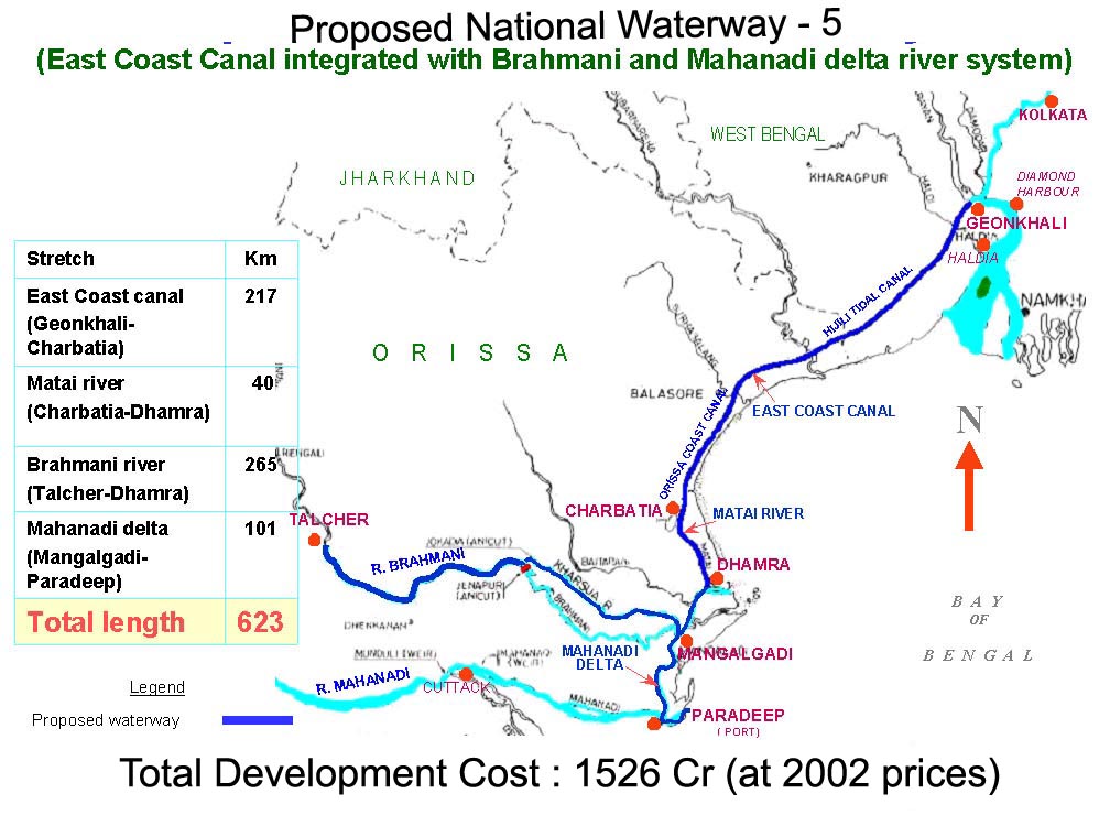
NATIONAL WATERWAY (TALCHAR-DHARMA STRETCH OF RIVERS, GEONKHALI-CHARBATIA STRETCH OF EAST COAST CANAL, CHARBATIA-DHAMRA STRETCH OF MATAI RIVER AND MAHANADI DELTA RIVERS) BILL-2006
AND

NATIONAL WATERWAY (KAKINADA-PONDICHERRY STRETCH OF CANALS AND THE KALUVELLY TANK, BHADRACHALAM-RAJAHMUNDRY STRETCH OF RIVER GODAVARI AND WAZIRABAD-VAJAYAWADA STRETCH OF RIVER KRISHNA) BILL-2006

THE MINISTER OF SHIPPING, ROAD TRANSPORT AND HIGHWAYS (SHRI T.R. BAALU) moving the motion for consideration of Bills, said:  From time immemorial, inland water transport has served as a cheap and economic means of transport in India.  With the advent of faster means of transport, i.e., rail, road and air, inland water transport has got neglected.  Inland water transport has, however, maintained its edge over the other modes of transport in certain areas where it enjoys natural advantages.  Its energy efficiency, low pollution and potential for employment generation are universally accepted.  Since independence, the Government is seized of the need for developing inland water transport infrastructure to restore its rightful place in the overall transport scenario of the country.  The subject of inland water transport finds place in all the three Lists of the 7th Schedule to the Constitution of India.  The role of the Union is, however, limited to regulating shipping and navigation on the national waterways declared, as such, by Parliament.  The responsibility and executive authority for development and maintenance of all waterways other than national waterways rest with the State Governments.  Keeping in view the slow pace of the development of inland water transport in our country, several Committees were constituted by the Government of India which have recommended declaration of certain important inland waterways as national waterways.  The Government of India has constituted Inland Waterways Authority of India for development, maintenance and regulation of national waterways for shipping and navigation.  The infrastructure facilities on the existing three national waterways are being created by it to make them fully functional.  Most of the State Government do not have resources to develop their waterways for shipping and navigation due to which most of the waterways remained totally neglected and unexploited for navigation.
 Before a waterway can be considered for being declared as a national waterway, it is essential to undertake techno-economic feasibility study including hydrographic survey and traffic studies of such waterways to assess the extent of improvement works required for their development and their financial implications.  Based on this study and the potential of improvements in inland water transportation, it is now proposed to declare some waterways mentioned in the Bills as national waterways.

 SHRI DHARMENDRA PRADHAN:  Infrastructural development is very important for economic development of our country.  Though, delayed, but then it is appreciable that a proper thinking regarding waterways in the country is taking shape.  Three waterways of Orissa have been mentioned.  I would like to mention Talwer.  It will become an important waterway. About 60 million tonne of coal is produced in this area.  Though, coal is mined, it is arduous to transport it.  It will be really a beneficial step to form a waterway for this purpose.  A water route has been formed by linking the tributaries of Mahanadi and Brahmani.  This is a matter of challenge.  We must have water in Brahmani river if at all we have to run it for the year along.  If there is a scheme through which Mahanadi water enters into Brahmani, it will keep Brahmani perennial. It shall be really very much beneficial if the Government of India, the Planning Commission and the Minister of Water Resources deliberate in this regard.


 SHRI LAKSHMAN SETH:  We have so many modes of transportation like airlines, railways and roads but waterways is also an important mode of transportation of our cargo and commodities.  This is very much neglected in our country.  Transportation through water is always cheaper, eco-friendly and environment-friendly so waterways should be developed.  Our experience is not so much satisfactory because already long before, one waterway, i.e. Allahabad and Haldia waterway, has been declared as a national waterway.  But, I think, infrastructure development has not taken place so far.  Terminal has not been done adequately and dredging has not been taken up to the considerable limit.  That is why, this important national waterway has not been used properly.

 Our nation is facing a severe crisis in fuel.  So fuel would be saved.  At the same time, environment will be certainly cleaned.  That is why there should be a law enforcing the public sector to use this mode of transportation in inland waterways so that the inland water becomes useful and at the same time the nation will also save huge money on account of fuel.

 The declaration of these two important waterways as a national waterway will help immensely irrigation and transportation of various types of cargoes and commodities.  At the same time, I am requesting the hon. Minister to declare the waterways from Haldia to Sundarban as a national waterway.  Another issue which I would like to bring to the notice of the hon. Minister is that in Bangladesh, there is an anchorage on the river Ashuganj.  If the Government of India can manage to have this anchorage then the distance between Halida, Kolkata and the North-Eastern States will be reduced remarkably and fuel will also be saved.   I congratulate the hon. Minister for bringing this Bill but at the same time I would request him to arrange adequate fund for implementation of the various infrastructural facilities.  Further, I would request you to look into the interest of the farmers.

            SHRI GANESH PRASAD SINGH:  The responsibility for the management of rivers lies with the State Governments but they do not have sufficient resources to shoulder this responsibility.  The travel by waterways is economical and time saving also.  This Bill envisages an Authority for the development of national waterways and sufficient amount of money has also been proposed to earmark for this purpose.   So this Bill is a welcome step.

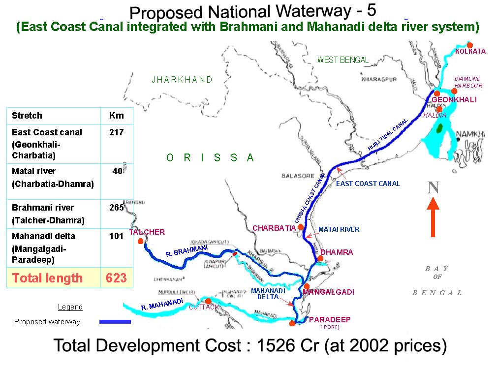
 SHRI B. MAHTAB:  It is said that the total length of navigational waterways in India is about 14,500 kilometres.  Of this, 5,700 kilometres is navigable by mechanically propelled vessels.  At present, the inland traffic is estimated at about 1,000 billion tonne kilometers and the inland water transport accounts for barely 0.17 per cent.   The House should know that IWT is not only environment-friendly, it is also less capital intensive.  Lack of infrastructure, absence of fixed scheduled services, poor navigational aids, lack of connectivity, longer river distances and thin flow of private investment are the major factors that have stifled the development of this mode of transportation. Now we are considering the East Coast canal integrated with the Brahmani River along with Mahanadi Delta Rivers.  It is said that around 18.07 million tones of inland water transport traffic is expected to be carried out on the proposed waterway after it is fully development in eight years time.  I would like to suggest that the Government should prepare a roadmap for an Integrated Transport Policy for enabling better inter-connectivity amongst the multiple modes of transport.  There have to be provisions for an institutional framework for development of inland water transport sector.  There is a need to increase cost recovery and also to commercialise IWT industries.  An Action Plan should be in place to address the growing demand of repair and service facilities of IWT vessels.  I hope, the proposed national waterways will boost the rural economy and help decongestion of roads and rails.  I hope it will provide port-hinterland connectivity, especially between Talcher to Dhamra.  It will generate employment and also increase tourism activities in that region. I am sure that the Government must have appointed a consultant for undertaking techno-feasibility study and preparation of detailed project report for this waterway.  I hope that the interest of Orissa will not be compromised due to development of this proposed national waterway.  Lastly, I must say that regular dredging of riverbeds would be necessary.  The infrastructure currently available on this waterway is not adequate for safe, convenient and sustained shipping and navigation purposes. Once it is developed, there is ample scope to have substantial quantum of inland water transport traffic, but first the parameters are to be met and that too, within a specific time frame.

 SHRI M. SREENIVASULU REDDY:  I rise to support this Bill.  All of us know that there are different modes of transport.  Waterway is the cheapest, though slow.  I am happy that Buckingham Canal-which flows through Ongole, which is my Parliamentary Constituency, has been included in this Bill for the development.  There has been a lot of pressure from people living in between Buckingham Canal and Bay of Bengal for construction of bridges to enable them to cross the canal. I request that the bridges at the required spots may be constructed immediately. The area covered between Kakinada and Chnnai along with rivers Godavari and Krishna as Waterway is 970 kms.   There are 14 terminals that are being planned in this Bill.  Out of these 14 terminals, in my Parliamentary Constituency there is only one terminal, which has been stipulated in this Bill.  I will request the hon. Minister to include two more terminals namely, at Karedur or Ramayapatnam and Thummalapantawar near Kavali. There is one more important point that waterways do not provide door-to-door service independently.  Therefore, it is necessary that these are connected with rail or road modes for total transport linkages.  In my Ongole Parliamentary Constituency there is lot of potential in Granite/tobacco/Garments, food grains, firewood, etc. and providing of connected mode of transport to Buckingham Canal will help a lot.   The Inland Waterways Authority of India could make the National Waterways functional fully subject to availability of funds. Any delay will only add to the miseries in the field of transport. Hence, I again impress upon both the Central and the State Governments for an urgent action in this regard.

 DR. BABU RAO MEDIYAM:  Supporting this Bill, I wish to say that the delta region around Krishna Godavari Rivers was developed almost 160 years ago during the British times.  The present canal system is being used only for irrigation purposes.  These canals are now under the control of the Irrigation Department, and the irrigation canals are being maintained and regulated by the Water Users Associations in our State.  Now, these canals are going to be used for navigational purposes and there is a lot to be done in this case.  I would request the Minister to take necessary action in this regard, especially on the stretch between Bhadrachalam and Rajahmundry.  There is a proposal for a great barrage of Polavaram.  This has to be linked to the existing canals.  The Irrigation Department is not spending even a pie on these canals.  If these canals come under the National Waterways Authority, then what would be the allocation?  What is the role of the Water Users Associations?   Moreover, the existing terminals on the banks of the River Godavari should be taken care.  If ever this Polavaram Dam project comes up, then most of these present terminals would be submerged.  To regulate everything, you have to explore this Bhadrachalam-Rajahmundry stretch of canal.  A lot needs to be done on the legal and financial front also.  Anyhow, I strongly support this Bill and I request this to be amended.

 SHRI ALOK KUMAR MEHTA:  I support this Bill.  I want to impress upon the authorities that, in 1985, the waterway from Allahabad to Haldia had been declared as the National Waterway.  One point of this waterway falls in Patna also.  Haldia Port is very near to this point.   In the beginning, points and ports had been constructed but lot of problems have cropped up, for want of proper dredging.  This waterway needs to be cleared.
Similarly, inland waterways system can be given a nod in view of the heavy traffic density in Patna.  The UPA Government would indeed do a great job if it declares it a National Waterway and undertake its maintenance and total infrastructure cost as it is beyond the capacity of any State Government alone.  However, if they undertake dredging the menace of flood can be averted to some extent along with the development of national waterways.

SHRI S.K. KHARVENTHAN: Inland water transport is an economical, fuel-efficient and employment-oriented transport.  The present waterways in the above ways are unsuitable for shipping and navigation.  Hence it is necessary to develop the infrastructure in river and canal portions by deepening and widening the bed for safe and convenient shipping operations.  The proposed infrastructural developments are planned to be completed within few years period in a phased manner.  I request the hon. Minister to take steps for completing the work as early as possible.
With the policy of economic liberalization Government of India has allowed private sectors for port development.  Hence, I request the hon. Minister to allow private participation in shipping in these stretches.  It will increase the service as well as employment opportunities for unemployed youths.  Another important aspect is regarding oil pollution in the above stretches.  Government has to take steps to establish Pollution Prevention Equipment in all terminals to protect and safeguard the river environment.  The Ministry also must take steps to provide all necessary facilities for day and night navigation.  Furthermore, the Government of India has to provide all assistance to states to develop other waterways in various States.

Inland Water Transport is one of the oldest and cheapest modes of transport.  But unfortunately, we have failed to develop it.  If the Ministry of shipping is taking a serious view on this subject, then it should and must come forward to allow Joint Venture of Private sector participation in this field.  The Standing Committee has also recommended Joint venture participation.  The Government should also concentrate on providing proper repair and regular servicing facilities for operating vessels in these waterways.

SHRI KHARABELA SWAIN: I thank the hon. Minister for introducing such a Bill.  However, I would like to emphasis upon the hon. Minister that nowadays most parts of the East Coast Canal passing through the district of Balasore have been encroached by various people.  In some places, there is virtually no sign of any canal because of the shrimp farming.  I shall appeal to the hon. Minister that he should see to it that the land which have been encroached by the land mafia should be recovered by the State Government.  Let the State Government take very stringent action with regard to this.  Then I come to the repair of the embankment.   In most places, there is no existence of any embankment now.  Those places should be developed.  If both sides of the embankment could be developed under the Pradhan Mantri Gram Sadak Yojana, it will also provide very quick communication facilities for the people.  This will also provide an embankment for the prevention of floods.  Further, in many places, the farmers have put cross bunds.  They have raised many other obstacles.  Thus there is no drainage water facilities available.  Hence if a canal is dug, it could be drained and a proper drainage water facility could be provided there.  That would also save a lot of people and a lot of property being destroyed every year due to flood.  While dredging this canal, he should also provide for some small bridges across the canal in regular intervals because cattle will cross, because people will be going to their paddy fields for cultivation along with their cattle, bullocks and cows.  So, all these things should be provided now in a planned manner.

 The hon. Minister is also requested to go for sluice gates in order to prevent the salty water of the sea entering into the paddy fields.  I will appeal to the hon. Minister that he should set a time frame for the completion of these projects.  Otherwise, for eternity they will remain on paper and they will not be implemented at all.

 SHRI ADHIR CHOWDHURY: India has already three National Waterways and we are going to have two more National Waterways.  But we have to have some introspection whether just declaring some waterways as National Waterways will serve the desired purpose.  India is a country which has been endowed by the nature of so many rivers.  In spite of the huge potentiality that we have in our country we are able to exploit a very negligible portion of our waterways.  In our multi-mode transport system, inland water is so negligible that inland water transport system enjoys less than one per cent.  The fact is that in spite of plenty of potentiality in so far as inland water transport system is concerned, we have grievously failed to exploit the enormous potentiality and the enormous advantages in terms of fuel efficiency, in terms of eco-friendliness.
 So, first of all, what I propose to the Government is that we should offer some lucrative incentive to the private sector so that they could be drawn to the inland water transport system.  Only by the endeavour of the Government, we cannot attain our desired goal and to draw the attention of the private sector.  Our nature has itself done the engineering work for the inland water transport.  Therefore, we have the enormous leverage in this sector. The cost of development inland waterways is 5 to 10 per cent of the cost of developing an equivalent rail way or a four-lane expressway.  Insofar as maintenance cost is concerned, the maintenance cost of an inland waterway is only 20 per cent of the maintenance cost of an equivalent roadway.  However, we have failed to exploit the potentiality.

 We know that the entire State of Assam is prone to flood.  The highest river route is available in Assam so, if we are able to develop an appropriate inland waterway system in the Assam Region, I think it will be a great benefactor to the entire North-Eastern Region.  Furthermore, it will add a new dimension to our Look East Policy also.  We can cover the North-East and West Bengal by the inland water transport system and the entire route could be shortened.  It will also entail the growth of trade and commerce.  The three national waterways are there. I would like to know whether we have achieved the target, the goal before commissioning of the other three national waterways.  It will indicate whether the further declaration of national waterways will be lip service or will be a real objective of our country.
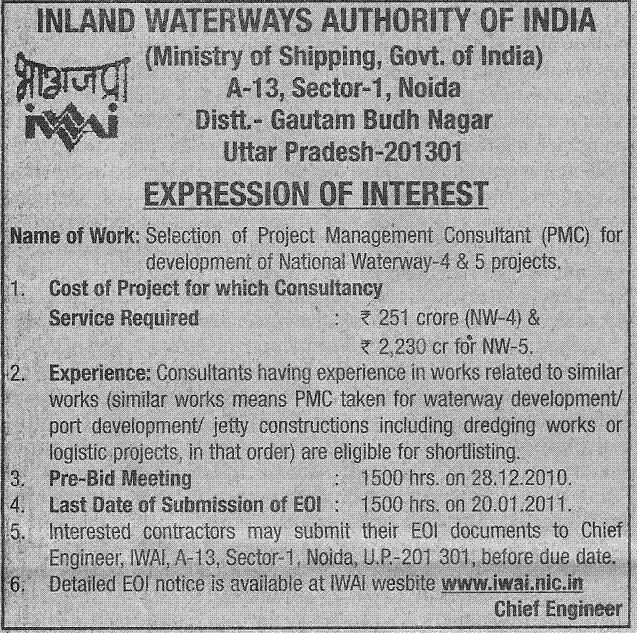
 I have a little confusion.  I would lime to know from the hon. Minister whether this amount of Rs.1,526 crore is the consolidated amount for both the national waterways or this amount pertains only to Geonkhali-Charbatia Stretch of East Coast Canal and the other amount of Rs.542 crore pertains to Kakinada-Pondicherry Stretch of Canal.  I once again appreciate our Government for bringing this Bill because when trade and commerce in our country is increasing, naturally we are facing a severe constraint in our existing modes of transport.  So, we need other avenues of transport and in this regard, inland waterways could be an ideal mode of transport in our country.

SHRI BHANU PRATAP SINGH VERMA:  Transportation of goods by roads is costly.  Whenever we have to send food articles to Kolkata, we do not get railway boggies as a result of which these articles of Bundelkhand and nearby areas do not reach Kolkata and other parts of the country.  Therefore, we want that inland waterway on the Yamuna river be restored and a port should be constructed at Kalpi Nagar so that unemployed youth of the above area could also get employment there.  Moreover, the waterways are also the cheapest means of transportation.

 SHRI SURESH PRABHAKAR PRABHU:  In fact, for a long-long time, the entire merchandise, the entire trade routes were passing through the great rivers of India.  Therefore, the waterways are not something new that we are innovating now.  Unfortunately, we neglected it and we are paying a price for it.  But I am very happy that now we are going back to the basics and we are now trying to create waterways for the country.  It will be cost-effective.  There several Ministries dealing with water.  The ministry of Shipping is now going to deal with one aspect of that.  So, when we are developing waterways.  I only hope and wish and really expect that the Ministry of Shipping will take into account the overall needs of the water sector in the country as a whole while planning this.  Floods have become common phenomena in India.  At the same time, some other parts of the country are constantly facing drought.  This is a golden opportunity; when the Minister is trying to create waterways for the country, why not also he integrates the drought and famine phenomena which happens all the time?

 SHRI GIRIDHAR GAMANG:  I support both these two bills because they would lead to economic development of the country and they would give new life to Indian inland waterways network.  There should be integration between your Department and the Department of the concerned State Government.  These two Departments will have to be integrated, not financially, but in respect of there aspects the Central Government will have to take the support of the State Government.

SHRI BIKRAM KESHARI DEO:  I completely support the Bill and welcome it because this will integrate the entire rivers with one another, and it will be direct link.  As the States do not have resources to develop inland waterways, it is high time that the Centre is now concentrating on developing these waterways.  Economically it is a very viable project.  You can use the flow of water for transportation of goods.   There has been a long standing demand in the State of Orissa that an Inland Waterways Regional Office should be opened because Mahanadi delta is a massive delta.  This will also enhance export and import activities.  Besides that, as Orissa is prone to natural disasters, this East Coast Canal, which we are developing now, will have a deterrent effect on storms and Tsunamis, and it will be a mode of transport to the entire interior Orissa.  After Independence, so many big water bodies, infrastructures and big dams have come up.  It is because of the formation of these dams and impounding of water, thousands of villages are on the other side of the reservoir thereby creating problems for the people to deliver the goods like PDS, health related activities, development activities, and transportation of people.  For example, in my constituency, Upper Indravati project is there.  It is a huge inland water reservoir covering 110 square kilometers.  It has with four dams and eight dykes.  There are about 72 villages on the other side of the reservoir.  So, to reach those 6-7 villages, we have to take a detour of nearly 100 kilometres.  But if the waterway is there, it will be about within 25 to 30 kimometres.  So, I request the hon. Minister, that the Inland Authority should be created for these big reservoirs for movement of PDS and for taking up other Government related activities.

 KUNWAR MANVENDRA SINGH (MATHURA):  I feel for the first time that after independence such a good bill has been introduced in the Parliament that is a welcome step as it would be beneficial.  Before Independence when the East India Company came to India it started inland waterway from East to West.  But gradually not much importance was given to it.  So its losses are before us today.  But today the need of the hour is that we should also gradually undertake such projects for other rivers of the country also.  Rs. 1000 crore were provided for cleansing the Yamuna river.  But we see that even after spending so much of money, sewer water and industrial waste are still being discharged into Yamuna which is really a cause of grave concern.

A project for the cleaning of the Rivers was undertaken during the regime of Late Rajiv Gandhiji, however, no special attention has been paid to this project.   River Yamuna is in a very bad condition today.  But we can develop it for waterways  which could include passenger transport as well.  If we can start waterways for passenger transport from Delhi to Agra, lakhs of tourists would travel thereby, thus developing it as a good mode of transport.  Besides, we can clean and beautify river Yamuna.  At the same time, rivers of the country need to be linked, as it would increase the flow of water in the river.  We would be able to ward off the damage caused by the floods and save crores of rupees and many lives. If we construct dams on the river, we would be able to generate hydro-power and provide irrigation facilities thereby curbing the menace of floods.  Likewise, a pollution free environment would be created and cheap mode of transport will be in place reducing the pressure on the roads.  It would help to set up new industries along the rivers in the remote areas. It would generate employment and develop the rural areas.  I would like to suggest that we need to formulate a comprehensive scheme for the rivers of the country.  Hon’ble Minister has taken a good initiative and I hope in the time to come, we will be able to develop a viable system and clean environment through our rivers in the country.

SHRI LAKSHMAN SINGH: Hon’ble Minister deserves to be congratulated for the Authority, which is sought to be set up.  However, we hope that the potential for the development through the rivers need to be properly addressed and considered.  We hope him to work with the national perspective.  We have a great potential in the North India. Likewise, there is a major river, Chambal, which flows perennially.   It has been included in the linking project too.  This river passes through three states i.e. Uttar Pradesh, Madhya Pradesh and Rajasthan.  If a waterway is developed through this river connecting these states, the problem of dacoity would be addressed to a great extent.  Besides, this mode of transport would be fairly cheaper and economical.

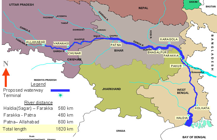
           SHRI T. R. BAALU replying said:  First of all, I would like to thank all the hon. Members who have deliberated in this discussion.  Definitely, all the deliberations that have been made by them are a matter of great guidance for me.  Since time immemorial, inland waterways transport has served as cheap and economic means of transport.  People are using this waterway transport as they are conscious of the issue of environment.  As you know, Allahabad-Haldia is Waterway No. 1, Sadiya-Dhubri is Waterway No. 2, and Kollam-Kottappuram is Waterway No. 3.  However, in all these three waterways, we could not achieve much success.  1985 onwards the Governments have not given the necessary attention towards this waterway system. The waterway transport has not developed to the extent other countries have developed it.  I would like to draw the attention of the august House to what we have done to develop inland waterways during the UPA period. A revised action plan for making the existing three national waterways fully operational has been drawn and it will be functional from 2010 onwards.  Funds have been provided to the extent of Rs. 961.64 crore. Investment of approximately Rs. 415 crore has been made between 2004 and 2009.  Seven terminals on National Waterway No. 3 at a cost of Rs. 10.32 crore have been constructed and commissioned. Low level jetty of a new fixed terminal capable of handling containers was constructed at Patna and high level jetty at Patna has been sanctioned.  Low level jetty at Pandu, Guwahati, on National Waterway No. 2 is nearing completion, and a high level jetty at Pandu on National Waterway No. 2 is under construction along with container handling cranes.  At various floating terminals, floating cranes and shore cranes have been provided.  Night navigation facilities have been installed in about 364 kilometres on National Waterway-1; 255 kilometres on National Waterway-2; and 100 kilometres on National Waterway-3.  Projects for providing state of the art 24-hour navigational aids on three National Waterways have been sanctioned and are under implementation.  Acquisition of six cutter section bridges, six watch boats, and six accommodation boats for carrying out dredging operations on National Waterway-1 and National Waterway-2 have been sanctioned.  Approval for setting up of six joint venture projects is on the anvil.  In response to suggestions and views expressed by the hon’ble Members, I would like to say that they would be duly considered .  In river Brahmani, accumulation of water will be ensured by constructing five barrages in that particular area. Environmental studies will be made.  Irrigation would not be affected.  We will definitely ensure that nobody staying nearby would be disturbed.  On irrigation and interests of the people living along the waterways, we will definitely consult the State Governments and do the needful.  As far as implementation plans are concerned, they have already been drawn and clearance have been obtained from the Planning Commission and the Finance Ministry.  Local irrigation interests will be taken care of.  We are giving priority to inland waterways transport.  We have already done the Techno-Economic Feasibility Study: DPRs are being prepared.  The DPRs which are under preparation would take care of terminal construction etc.  The social problems will be handled only after providing alternative arrangements. Definitely, we would come forward with an Integrated Water Transport Policy in consultation with all the Departments. After the addition of two national waterways, total length of waterways would become 4,460.   By 2020 the share of inland waterways traffic would be not less than two per cent.
 

An amount of Rs.1525 crore is identified for Talcher-Dhamra waterways and an amount of Rs.542 crore is identified for Kakinada-Pondicherry waterways.  An Hon. Member has said that we should encourage Inland Waterways Authority of India to function better by opening a regional office in Orissa.  It is proposed to open an office in Orisa; presently, it is planned at Dhamra-Charbatia.  We should see that whatever waterways that have already been declared, should be made functional; that is more important.

The Bill, as amended, was passed.
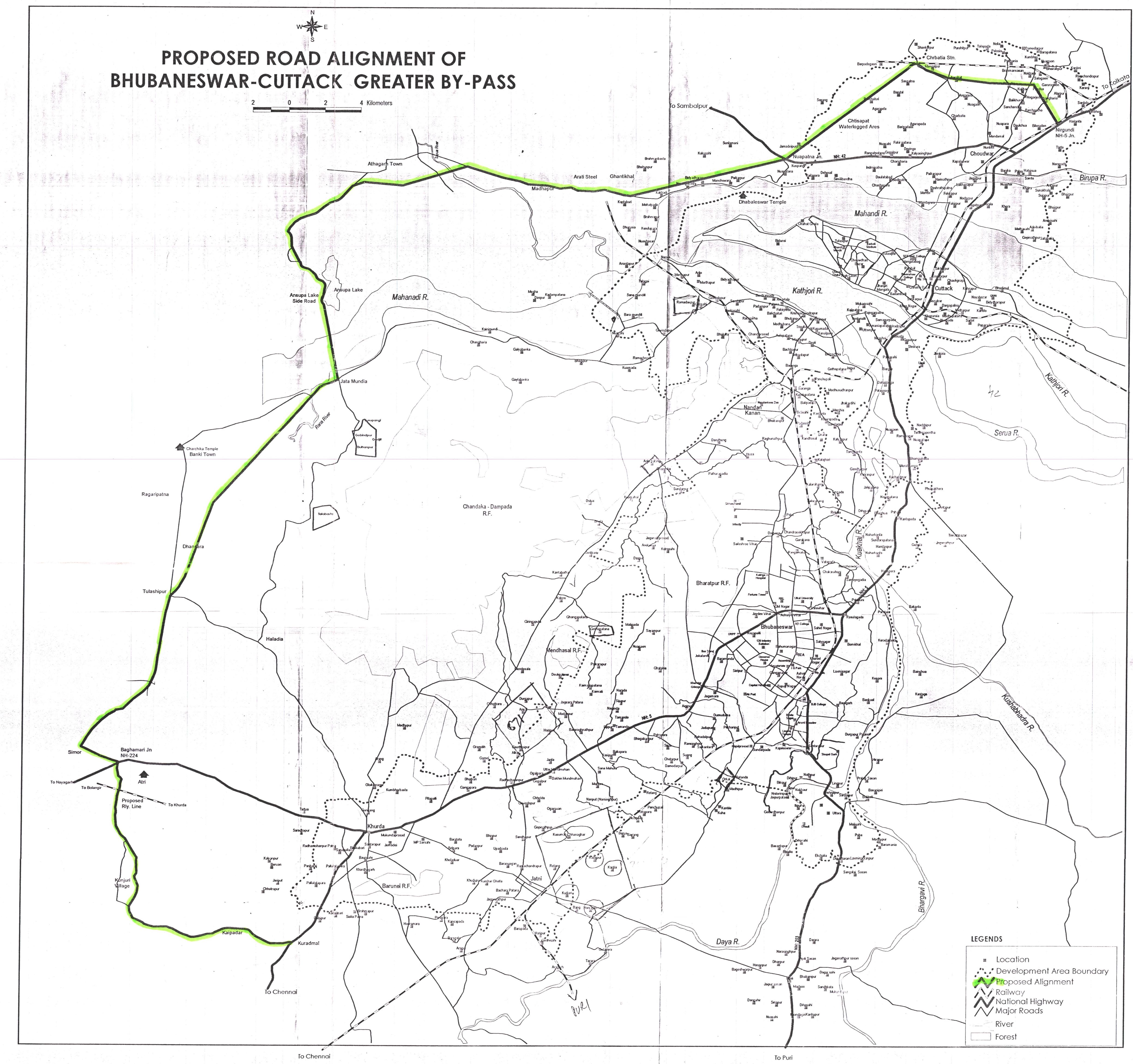
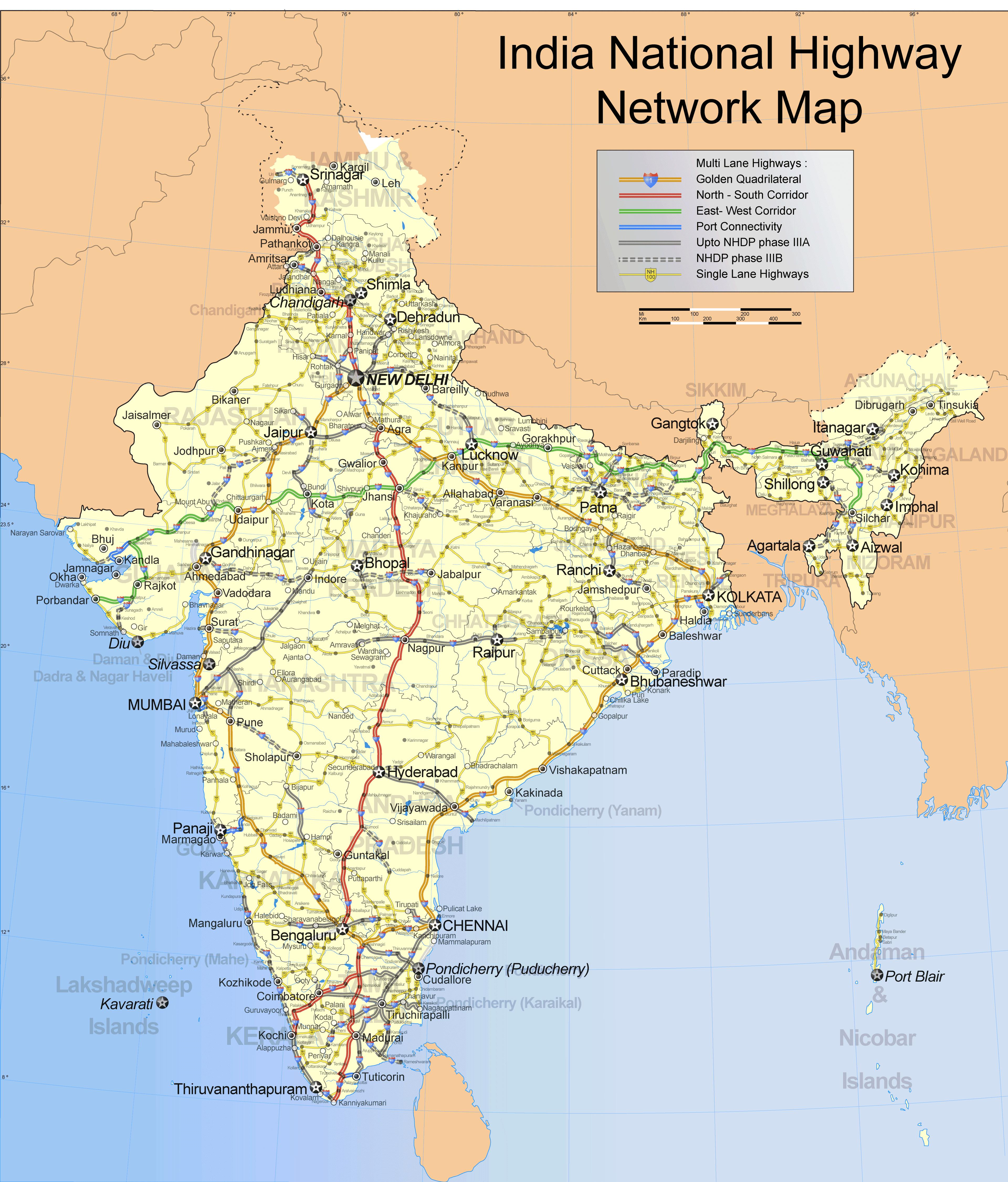
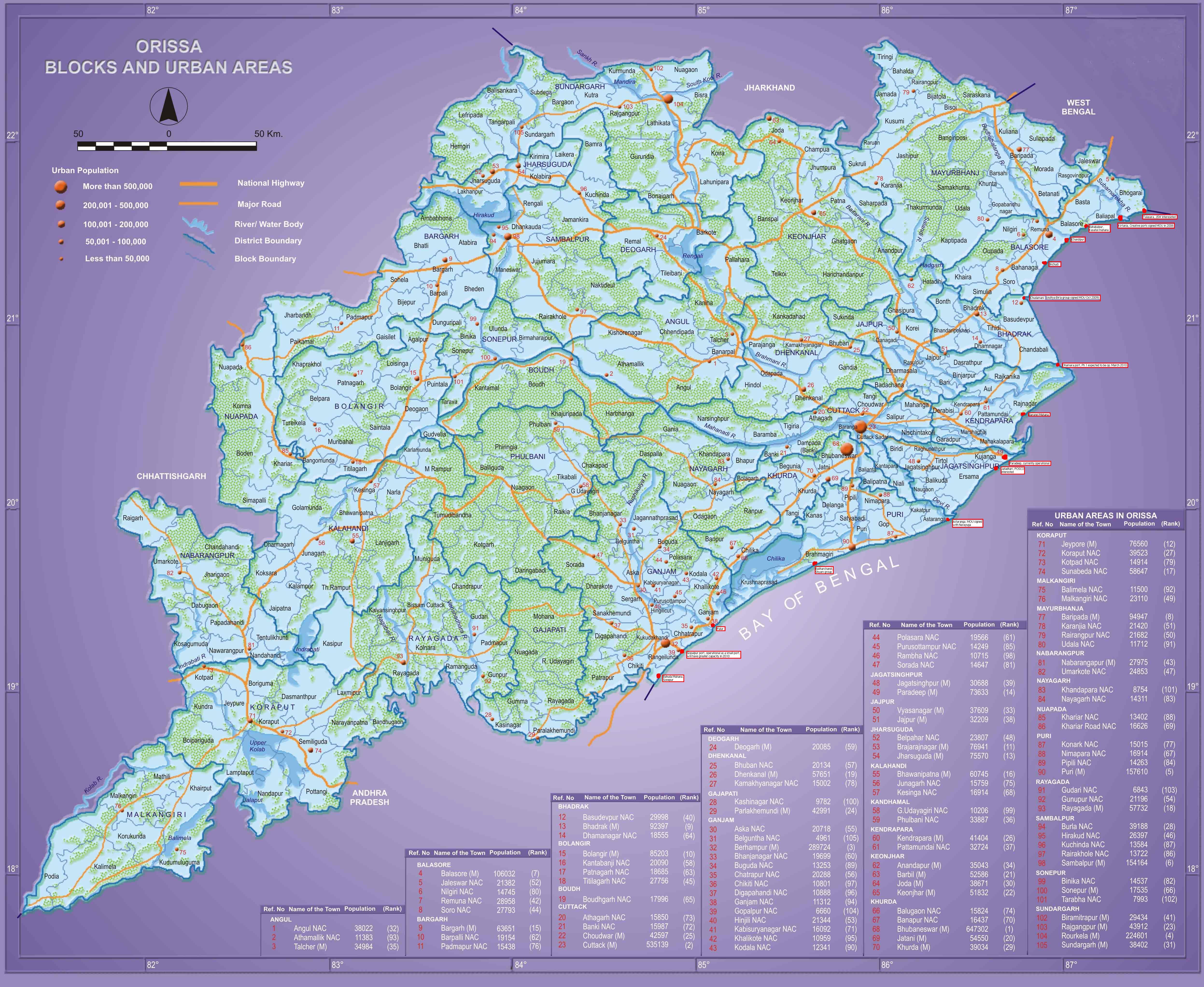
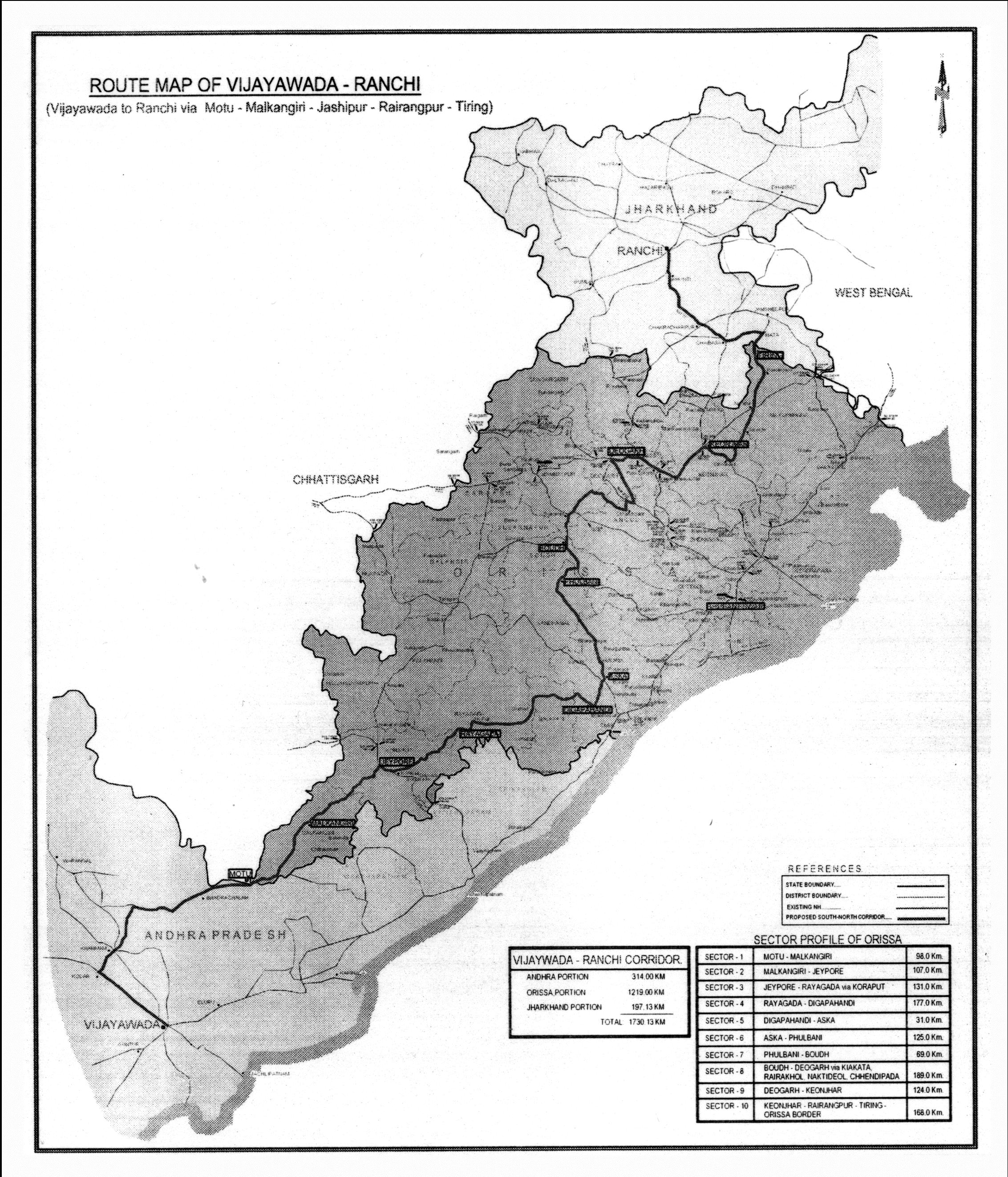
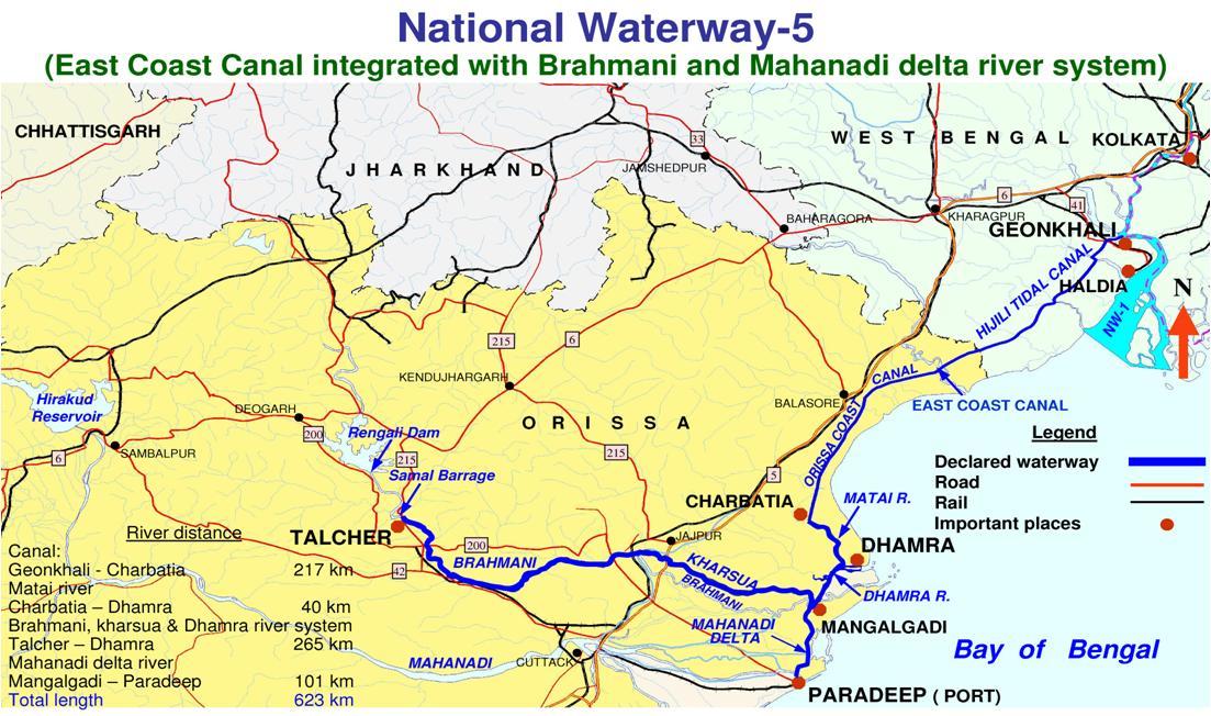
Orissa plans to augment National Waterway 5 with additional river routes

Balasore, Inland waterways, Kendrapada, Khordha, National Waterway 5, Puri, State river routes Comments Off on Orissa plans to augment National Waterway 5 with additional river routes

As per a report in Telegraph these routes are:

  • Jaleswar – Kirtania on Subarnarekha
  • Balasore – Chandipur on Budhabalanga (12 km)
  • Rajnagar – Aul , Aul – Aetepur and Singhapur – Aul on Kharsuan (63 km)
  • Rushikulya – Badanadi on Rushikulya
  • Netapur – Pathna on Kushabhadra
  • Kundhei – Siroi on Prachi
  • Balabhadrapur – Nuagarh on Daya (9 km)

Following is an excerpt from that report in Telegraph.

The state government has initiated steps to conduct surveys to identify river stretches having the potential for detailed hydro-graphic surveys and detailed project reports.

Rail India Techno Economic Services (RITES) has been engaged by the state government for conducting the studies, …

As many as 13 rivers … were identified by the government for the studies.

Of them, a 12km stretch of Budhabalang, three stretches comprising a total of 63km in the Kharsuan and 9km of the Daya have been identified for further detailed hydro-graphic surveys and traffic studies to be conducted by RITES.

Also locations, for the provision of infrastructure, would also be identified in these stretches, officials said.

According to preliminary studies, the identified rivers have enough potential and economic viability to serve as an effective waterway.

RITES has, therefore, suggested the development of an inland water transport corridor comprising three stretches of the Kharsuan river from Rajnagar to Aul-Singhpur-Aetpur and extend it up to Jajpur along the Brahmani.

The body has proposed to develop another corridor on the Daya up to Balugaon on the banks of the Chilika lake.

At present, the state directorate of ports and inland water transports run passenger launch services in Chandbali, Chilika and Astarang.

Initiatives are being taken by the directorate to start motor launch service in reservoirs of major and medium dam projects.

A river project report for construction of jetties and waiting halls in navigational routes at a cost of Rs 5.34 crore, prepared by ocean engineering centre of the IIT, Chennai, has been submitted to Nabard for assistance under the Rural Infrastructure Development Fund.

Orissa govt. action on the National Waterway 5

National Waterway 5, Odisha govt. action Comments Off on Orissa govt. action on the National Waterway 5

Earlier we discussed the national waterway 5. It seems finally the state government has woken up and ready to do its part. Following is an excerpt from a report in Telegraph.

Plans are afoot to develop a national waterway (NW-5) connecting the Brahmani and Mahanadi with the now-defunct East Coast Canal of the British days, extending up to Geonkhali in Bengal, at an estimated cost of Rs 2,000 crore.

As a follow-up measure, the Orissa government today set up a task force, headed by the development commissioner and secretaries of water resources, commerce and transport, forest and environment and revenue departments, to work out an action plan.

… The proposed waterway is being seen as an alternative to the congested rail and road routes.

An estimated 18.07 million tonnes of inland water transport traffic is expected to be carried out on the waterway in the 10th year of its commissioning, said commerce and transport secretary Suresh Chandra Mohapatra.

Cargo, such as coal, fertiliser, cement, iron ore, paddy, rice, seeds, coconut, wheat, sugar, edible oils, bamboo, straw, jute and industrial products may be transported through the route.

The proposed waterway includes a 91km stretch in Bengal (Geonkhali to Nasirabad), while the rest (532km) would be in Orissa.

A bill was introduced in Parliament on December 8, 2006, for the declaration of the Talcher-Dhamra stretch of the Brahmani-Kharsuan-Dhamra rivers, Geonkhali-Charbatia stretch of the East Coast Canal, Charbatia-Dhamra stretch of the Matai and the Mahanadi delta rivers between Mangalgadi and Paradip as national waterways.

… Preparation of the detailed project report has been entrusted with the Gurgaon-based Wapcos (India) Limited, while the preparation of the final report is underway.

Similarly, environmental impact assessment study and preparation of environment management plan are also on, Mohapatra said.

New Delhi-based CES (India) Private Limited submitted the final draft report of the environmental impact study to the Union government last year.

While the Union government would be funding the project, the state government will provide the required land, free of cost.

The land acquisition process and rehabilitation of people living along the 100m wide corridor is to be initiated by the government, besides providing technical details and data to consultants for completing the detailed project report.

The major works include construction of four barrages at an estimated cost of Rs 900 crore, renovation of 217km East Coast Canal, widening of narrow canals, modification of bridges and roads, bank protection and setting up four terminals at Talcher, Balasore, Nasirabad and Rajnagar.

The minimum bed width and depth of the waterway (for 406 river delta portion) will be 45m and 2m respectively to handle vessels of 500tonnes carrying capacity.

In the first phase, the bed width and depth for the 217km East Coast Canal portion will be 32m and 1.5m respectively for vessel size of 200 tonnes.

Status of national waterways

National Waterway 5 2 Comments »

Following is from http://pib.nic.in/release/release.asp?relid=.36825.

RAJYA SABHA


The Government has declared three rivers/canal system, as National Waterways namely (i) the Ganga from Allahabad to Haldia (1620km) (ii) the Brahmaputra from Sadiya to Dhubri (891km) and  (iii) the West Coast Canal from Kollam to Kottapuram along with Champakara and Udyogmandal canals (205km). Basic infrastructural facilities for shipping and navigation namely navigational channel, navigational aids, and terminals are being provided on these National Waterways. 

Further, following three rivers/canal systems are in the process of declaration as National Waterways.

(i)         Kakinada-Puducherry Canals along with rivers Godavari and Krishna (1095km).

(ii)        East Coast Canal along with river Brahmani and Mahanadi Delta (623km).

(iii)        River Barak (121km).

An action plan has been drawn up to make the three existing National Waterways fully functional by March 2010, subject to availability of funds. 

This information was given  by the Minister of Shipping, Road Transport and Highways, Shri T.R. Baalu in a written reply in the Rajya Sabha today.

National Waterway 5 bill to come up in Lok Sabha today

Key Center-State issues, National Waterway 5 Comments Off on National Waterway 5 bill to come up in Lok Sabha today

Update: It could n’t come up on the 26th (item 17) as the Lok Sabha was adjourned after the Railway budget. It was scheduled to come up on the 27th (page 4), but  the Lok Sabha was again adjourned following protests by NDA and others raising the issue of the farmer’s plight.  Its scheduled to come up again on the 28th. But again the house was adjourned till the next day just about when this item was supposed to come.

The following is from http://164.100.24.207/lobtext/14/XIII/RLOB26.2.2008.pdf. (Our earlier coverage of this was in http://www.orissalinks.com/orissagrowth/?p=445)

One step closer for the national waterway in Orissa

Angul, Balasore, Bhadrakh, CENTER & ODISHA, CORRIDORS, Cuttack, Dhenkanal, INVESTMENTS and INVESTMENT PLANS, Jagatsinghpur, Jajpur, Kalinganagar - Kamkhya Nagar - Talcher, Kalinganagar - Panikoili - Jajpur - Kendrapara, Kalinganagar corridors, Kalinganagar- Chandikhol- Paradip, Kendrapada, National Waterway 5, Ports and waterways Comments Off on One step closer for the national waterway in Orissa

Some of the earlier news reports on national waterways in Orissa are linked from this site. Following is the latest development, as reported in an Indian Express article. Excerpts:

The Parliamentary Standing Committee has shown the green signal to two new national waterways in West Bengal-Orissa and Andhra Pradesh-Tamil Nadu even as it called for an integrated transport policy and an institutional framework for inland water transport. … The other waterway—Talcher-Dhamra stretch of the Brahmni-Kharsua-Dhamra Rivers, Goenkhali-Charbatia stretch of the East Coast canal, Charbatia-Dhamra stretch of Matai River and Mahandai delta rivers between Mangalgadi and Paradip is also up for the national waterway status. Around 18.07 million tonnes of inland water transport traffic is expected to be carried out on the proposed waterway after its full development in eight years time. The traffic is expected to be handled at four terminals—Talcher, Nasirabd, Balasore and Rajnagar and the major cargoes are coal, fertiliser, cement, iron ore, agricultural and industrial products. The Standing Committee, however, has recommended the Government to prepare the road map for an integrated transport policy to include inland water transport, coastal shipping, civil aviation, road transport & highways for enabling better inter-connectivity amongst multiple modes of transport. The Committee has also called for provision of an institutional framework for development of IWT sector so as to increase capacity of IWT agencies, increased cost recovery and commercialisation of IWT industries. In case of the West Bengal-Orissa waterway, the Committee has suggested that another terminal be developed at Geonkhali in West Bengal to enable better traffic handling. It was also noted by the panel that there’s need to develop an action plan to address the growing demand of repair and service facilities of IWT vessels.

The final step for the bill would be to getting approval in both houses of the parliament. nw5.jpg

Following up on the standing committee’s recommendation it may be appropriate to establish an airport near Jenapur-Kabatabandha as the ECOR Howrah-Chennai Railway line and NH 200 (Chandikhol-Sukinda-Talcher) intersects the national waterway at that point; NH 5A (Chandikhol-Paradip), NH 5 (Panikoili-Chandikhol) and NH 215 (Panikoili-Keonjhar) are close by; Haridaspur – Paradeep railway line will start very near to that point; Jakhapura-Banspani line also starts close to that point and that airport will serve the greater Kalinga Nagar area where multiple steel plants and other plants are coming up. Going further on that, the Orissa government is supposed to have made a master plan for Kalinga nagar. Following is an excerpt from a year old report (May 28, 2006) in Steelguru on that. (See also this New Indian Express report)

Orissa government has decided to prepare a master plan for Kalinga Nagar in Jajpur district. South Africa based Lea Associates will prepare the master plan in collaboration with School of Planning and Architect, New Delhi and the Centre for Environment and Planning. The master plan will be completed by July. Kalinga Nagar Industrial Area will be developed for a population of over 10 lakh keeping an eye on 2025 and will be extended to 177 square kilometers. As per the draft, the KNIA will be extended to 134 villages. So far 112 villages have been included in the industrial area. About 1 million hectare land will be acquired by the Government in a phased manner for the development of the area. According to the draft plan, 68 square kilometer out of the total area will be reserved for town planning. About 89 square kilometer will be earmarked for industrial units while 20 square kilometer will be reserved for development of different infrastructure including bus stand, hotels, schools and hospital. Decision has also been taken to set up Kalinga Nagar Development Authority.